Reigate and Banstead Borough Council Coat of Arms, Reigate Town Hall
Introduction
The photograph on this page of Reigate and Banstead Borough Council Coat of Arms, Reigate Town Hall by Ian Capper as part of the Geograph project.
The Geograph project started in 2005 with the aim of publishing, organising and preserving representative images for every square kilometre of Great Britain, Ireland and the Isle of Man.

There are currently over 7.5m images from over 14,400 individuals and you can help contribute to the project by visiting https://www.geograph.org.uk
Reigate and Banstead Borough Council Coat of Arms, Reigate Town Hall
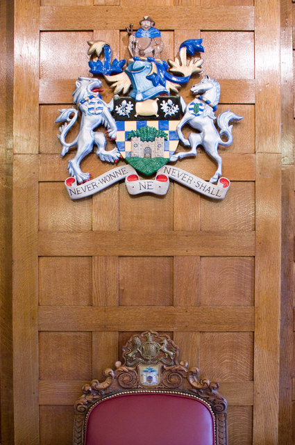
Image: © Ian Capper Taken: 11 Sep 2010
Close up of the coat of arms in the New Council Chamber (see Image). Compare the coat of arms of the original Borough of Reigate (see Image), the area of which was expanded following local government reorganisation in 1974. Although based around the original arms (and its subsequent successor, a new set having been granted in 1951), including retention of the original motto, it had components added representing the new areas added to the Borough, namely Banstead to the north and Sidlow, Salfords and Horley to the south. See http://www.ngw.nl/int/gbr/r/reigateb.htm for full description. Note the arms of the original Borough in the Mayor's Chair, the top of which can be seen at the foot of the photo.
Images are licensed for reuse under creativecommons.org/licenses/by-sa/2.0
Image Location
Latitude
51.239646
Longitude
-0.205047