IMAGES TAKEN NEAR TO
Wray Common Road, REIGATE, RH2 0UH
Introduction
This page details the photographs taken nearby to Wray Common Road, RH2 0UH by members of the Geograph project.
The Geograph project started in 2005 with the aim of publishing, organising and preserving representative images for every square kilometre of Great Britain, Ireland and the Isle of Man.

There are currently over 7.5m images from over14,400 individuals and you can help contribute to the project by visiting https://www.geograph.org.uk
Image Map
Images are licensed for reuse under creativecommons.org/licenses/by-sa/2.0
Notes
- Clicking on the map will re-center to the selected point.
- The higher the marker number, the further away the image location is from the centre of the postcode.
Image Listing (93 Images Found)
Images are licensed for reuse under creativecommons.org/licenses/by-sa/2.0
Image
Details
Distance
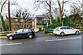
1
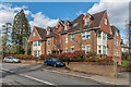
Rosehill
Block of 11 flats on the corner of Doods Way and Wray Common Road completed in 2006, replacing a large early 20th Century house of the same name.
Image: © Ian Capper
Taken: 12 Apr 2021
0.00 miles
2
Rosehill
Block of 11 flats on the corner of Doods Way and Wray Common Road completed in 2006, replacing a large early 20th Century house of the same name.
Image: © Ian Capper
Taken: 19 May 2020
0.01 miles
3
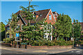
Doods Place
1960s apartment blocks at the junction of Doods Road and Wray Common Road, built on the site of Little Doods Farm, later known simply as Doods.
Image: © Ian Capper
Taken: 15 May 2020
0.03 miles
4
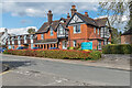
Wray Common Nursing Home
Nursing home on Wray Common Road, the core of which is a large late Victorian house named Woodthorpe.
Image: © Ian Capper
Taken: 12 Apr 2021
0.03 miles
5
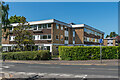
Dorchester Court
c.1960s block of flats in a former sand quarry off Wray Common Road. Because of its situation, the main access is towards the top of the building, as seen here.
Image: © Ian Capper
Taken: 18 Jan 2021
0.03 miles
6
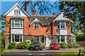
Carr End
Large house in Doods Way designed by local architect Albert Venner, dating from 1885.
Image: © Ian Capper
Taken: 15 May 2020
0.04 miles
7
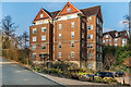
Valley Court
Block of flats in a former sand quarry off Wray Common Road, completed in around 2012.
Image: © Ian Capper
Taken: 1 Mar 2021
0.04 miles
8
Valley Court
Block of flats in a former sand quarry off Wray Common Road, completed in around 2012.
Image: © Ian Capper
Taken: 18 Jan 2021
0.04 miles
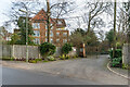
9
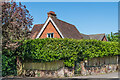
Hetherwood Lodge
1860s lodge at the junction of Doods Road and Wray Common Road, possibly originally serving a house in Doods Road called Lexden House (since demolished), and later included in the grounds of Hetherwood, now nos 92 - 94 Doods Road (see Image).
Image: © Ian Capper
Taken: 15 May 2020
0.04 miles
10
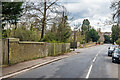
Wray Common Road
A pair of railway bridges on Wray Common Road. The nearer wall was originally for the bridge carrying the road over a siding that served a former sand quarry situated here, with the one beyond crossing the Redhill - Reigate railway.
Image: © Ian Capper
Taken: 12 Apr 2021
0.05 miles