IMAGES TAKEN NEAR TO
Chanctonbury Close, PULBOROUGH, RH20 4AR
Introduction
This page details the photographs taken nearby to Chanctonbury Close, RH20 4AR by members of the Geograph project.
The Geograph project started in 2005 with the aim of publishing, organising and preserving representative images for every square kilometre of Great Britain, Ireland and the Isle of Man.

There are currently over 7.5m images from over14,400 individuals and you can help contribute to the project by visiting https://www.geograph.org.uk
Image Map (Loading...)


Getting Data...Please wait
Leaflet Map data © OpenStreetMap
Images are licensed for reuse under creativecommons.org/licenses/by-sa/2.0
Notes
- Clicking on the map will re-center to the selected point.
- The higher the marker number, the further away the image location is from the centre of the postcode.
Image Listing (117 Images Found)
Images are licensed for reuse under creativecommons.org/licenses/by-sa/2.0
Image
Details
Distance
1
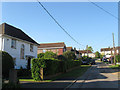
Chanctonbury Close
The southern end of the cul de sac was originally built as a council estate at the end of the 1940s. The close lies off School Lane.
Image: © Simon Carey
Taken: 27 May 2013
0.02 miles
2
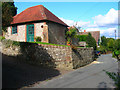
The Old Laundry, School Lane
Now seems to be a small dwelling though I am not certain. The building beyond is St Mary's Primary School stilloperating from its original building constructed in 1867.
Image: © Simon Carey
Taken: 2 Oct 2008
0.03 miles
3
St Mary's Church of England First School
Opened in 1867 and still going today primarily catering for 4-10 year olds. Located in School Lane.
Image: © Simon Carey
Taken: 27 May 2013
0.04 miles
4
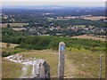
Downland village
This is a view of Washington in West Sussex. The bridleway is entering a disused chalk pit. Central to the skyline is Blackdown, which is the highest point in all Sussex. The headland on the horizon to the left of the picture is Bexleyhill but the picture quality is not sufficient to show the mast.
Image: © Shazz
Taken: 30 Jul 2010
0.05 miles
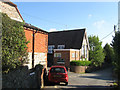
5
The Holt
A small cul de sac built south of School Lane during the 1950s.
Image: © Simon Carey
Taken: 27 May 2013
0.05 miles
6
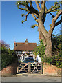
The Old Forge
Located at the corner of School Lane and The Holt. The house dates from 1732 and the old smithy was once located in the north east corner of the current garden.
Image: © Simon Carey
Taken: 27 May 2013
0.05 miles
7
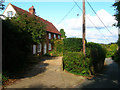
South Cottage, School Lane
Late 18th century/early 19th century cottage halfway down the hill of School Lane.
Image: © Simon Carey
Taken: 2 Oct 2008
0.05 miles
8
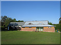
Washington Village Hall
A recreation room existed on this site on the 1911 OS map but was rebuilt after the First World War to serve as the village hall. The extension was added in 2006.
Image: © Simon Carey
Taken: 27 May 2013
0.06 miles
9
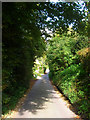
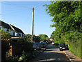
School Lane
Once the main northern route out of the village, it was superseded by Washington Bostal to the east, a 17th century by-pass road if you look at it. The lane now starts at The Street before turning east towards its replacement.
Image: © Simon Carey
Taken: 2 Oct 2008
0.06 miles
10

Washington Village Hall
The original hall to the left was built from charitable donations after the 1st World War and extended in 2006.
Image: © Peter Holmes
Taken: 20 May 2008
0.07 miles