IMAGES TAKEN NEAR TO
Hurstwood Lane, HAYWARDS HEATH, RH17 7QX
Introduction
This page details the photographs taken nearby to Hurstwood Lane, RH17 7QX by members of the Geograph project.
The Geograph project started in 2005 with the aim of publishing, organising and preserving representative images for every square kilometre of Great Britain, Ireland and the Isle of Man.

There are currently over 7.5m images from over14,400 individuals and you can help contribute to the project by visiting https://www.geograph.org.uk
Image Map
Images are licensed for reuse under creativecommons.org/licenses/by-sa/2.0
Notes
- Clicking on the map will re-center to the selected point.
- The higher the marker number, the further away the image location is from the centre of the postcode.
Image Listing (35 Images Found)
Images are licensed for reuse under creativecommons.org/licenses/by-sa/2.0
Image
Details
Distance
1
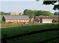
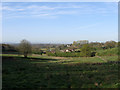
Hurstwood Grange
A small business park that occupies the former buildings of Hospital Farm, once owned by St Francis Hospital to provide provisions and employment for patients. This ended when a change in law in 1970 forbade the use of patients in employment and the farm was sold off in 1978. The former hospital, now converted to residential use, can be seen further up the hill. The gap between will eventually be filled by the course of the Haywards Heath relief road currently being constructed and due to be completed in 2015.
Image: © Simon Carey
Taken: 30 Apr 2011
0.02 miles
3
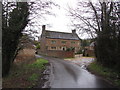
Hurst House
Former farmhouse that dates back to the 17th century. The original family called Hurst set up the farm in the medieval period and had become successful brickmakers by the 16th century building this house with the both their technical expertise and money they had made from that trade. Known as Hursthouse Farm until the 1860s when land to the north was sold to facilitate the construction of the Sussex County Lunatic Asylum. The farm was renamed Asylum Farm when acquired by it in order to provide provisions and employment for the patients in keeping with the Victorian ideal of self sufficiency. When the asylum became a mental hospital in 1919 the farm also changed its name to Hospital Farm and continued being part of the hospital until a new law was passed in 1970 forbidding patients from any employment within the hospital. The farmhouse and outbuildings were sold off in 1978 with the latter becoming a business park, Image, with the farmhouse eventually reverting to its original name having become a private residence. Viewed from the access road to Hurstwood Grange.
Image: © Simon Carey
Taken: 30 Apr 2011
0.05 miles
4
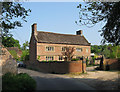
Carthouse Plot
The name of the field according to Wivelsfield's 1843 tithe map with the buildings of Hospital Farm in the dip. This view will change in the next year or two as the Haywards Heath relief road will be built beyond the former farm buildings. The farm itself was originally known as Hurst Farm but was purchased by the newly constructed St Francis Hospital in the 1860s to provide both food and work for their patients. Known as Asylum Farm before its present name it became redundant in 1970 when laws were changed preventing patients from working. It is now a small business park.
Image: © Simon Carey
Taken: 10 Apr 2011
0.05 miles
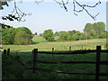
5
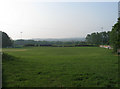
Orchard Field
The name of the field according to Wivelsfield's 1843 tithe map whose days are numbered as the Haywards Heath relief road is due to built in the next few years. Its projected route will run from the right of Hospital Farm in the dip below and head straight through the point where I am standing joining the A272 at the current junction with Hurstwood Lane.
Image: © Simon Carey
Taken: 10 Apr 2011
0.09 miles
6
The Lag
The name of the field according to Wivelsfield's 1843 tithe map viewed through a gap in the trees lining Hurstwood Lane. The houses in the far distance are on Fox Hill, the B2112.
Image: © Simon Carey
Taken: 30 Apr 2011
0.11 miles
7
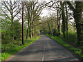
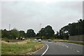
Hurstwood Lane
Small country lane that links Fox Hill, the B2112, to Lewes Road, the A272. A bit of a rat run at the moment due to roadworks building the Haywards Heath relief road which will utilise the eastern end of this lane when finally built. The lane is an old drove road that once led to wood pastures in what is now Franklands Village.
Image: © Simon Carey
Taken: 10 Apr 2011
0.13 miles
8
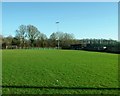
The Colwell Ground, home of St. Francis Rangers FC
The team play in the Sussex County League.
Image: © nick macneill
Taken: 1 Jan 2013
0.13 miles
10
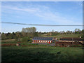
Colwell Ground
Home to St Francis Rangers who play in Sussex County Division One. The club began life as St Francis Hospital and were admitted to the Sussex County League in 1983. They became St Francis in 1999 after the closure of the hospital and merged with Ansty Rangers in 2002 to become St Francis Rangers. The ground belongs to St Francis Sports and Social club which has its origins as the former hospital's staff sports club which runs a number of different sports from the grounds including cricket, stoolball and hockey. They also run a bowls club and own Image The area has been landscaped out of three former fields which according to the Wivelsfield tithe map of 1843 were Russell Field, Acre Plot and Four Acres.
Image: © Simon Carey
Taken: 30 Apr 2011
0.15 miles