IMAGES TAKEN NEAR TO
London Road, HAYWARDS HEATH, RH17 5QD
Introduction
This page details the photographs taken nearby to London Road, RH17 5QD by members of the Geograph project.
The Geograph project started in 2005 with the aim of publishing, organising and preserving representative images for every square kilometre of Great Britain, Ireland and the Isle of Man.

There are currently over 7.5m images from over14,400 individuals and you can help contribute to the project by visiting https://www.geograph.org.uk
Image Map
Images are licensed for reuse under creativecommons.org/licenses/by-sa/2.0
Notes
- Clicking on the map will re-center to the selected point.
- The higher the marker number, the further away the image location is from the centre of the postcode.
Image Listing (13 Images Found)
Images are licensed for reuse under creativecommons.org/licenses/by-sa/2.0
Image
Details
Distance
1
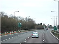
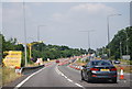
London Road
The old course of the A23 is about to rejoin the new route opened in the early 1990s to bypass Bolney, the two way lanes end at the drive to Beggars Bush Cottage on the left. The slip road is by and large used for access to services at Image
Image: © Simon Carey
Taken: 25 Sep 2014
0.06 miles
3
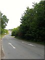
Beggars Bush
The name of the field according to Bolney's 1842 tithe map that lies to the west of London Road, the old course of the A23. The gate to the field has Beggars Bush Nursery painted on it which may explain the origins of what looks like a set of concrete storage areas.
Image: © Simon Carey
Taken: 25 Sep 2014
0.08 miles
5
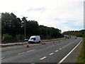
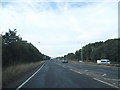
A23(T)
Looking southwards towards the junction with the northbound slip road out from Bolney, a point where the old course of the road rejoins the new course opened in the early and taking the trunk road past the village. Roadworks are currently in progress to extend the lanes and make the area around Handcross Hill safer.
Image: © Simon Carey
Taken: 25 Sep 2014
0.09 miles
8
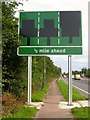
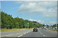
N20 Cycle Path
The long distance route links Wandsworth in London to Brighton and largely follows the A23 throughout its route. Here the path runs next to the road between the northern Bolney slip road and Pitts Head Crossroads where it splits, one route continuing to follow the A23, and another veering north eastwards following the old course of the London-Brighton turnpike to Staplefield then Handcross. The new sign awaits the work on the A23 to be completed before its instructions are revealed.
Image: © Simon Carey
Taken: 25 Sep 2014
0.16 miles
9
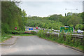
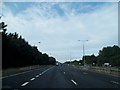
Old A23 and new A23
The old alignment comes to an end. It eventually continues some way along on the far side of the new alignment, where it is used as a slip road. The blue sign advises that unmarked police cars are operating. This is no idle threat, and they have used some unlikely makes such as Subaru.
Image: © Robin Webster
Taken: 16 May 2010
0.17 miles