IMAGES TAKEN NEAR TO
The Street, HAYWARDS HEATH, RH17 5PJ
Introduction
This page details the photographs taken nearby to The Street, RH17 5PJ by members of the Geograph project.
The Geograph project started in 2005 with the aim of publishing, organising and preserving representative images for every square kilometre of Great Britain, Ireland and the Isle of Man.

There are currently over 7.5m images from over14,400 individuals and you can help contribute to the project by visiting https://www.geograph.org.uk
Image Map
Images are licensed for reuse under creativecommons.org/licenses/by-sa/2.0
Notes
- Clicking on the map will re-center to the selected point.
- The higher the marker number, the further away the image location is from the centre of the postcode.
Image Listing (67 Images Found)
Images are licensed for reuse under creativecommons.org/licenses/by-sa/2.0
Image
Details
Distance
1
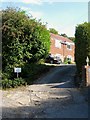
Franc-Jean Farm , The Street, Bolney
Not marked on the 1977 OS map but does appear on 1994 edition which gives some indication of its construction. Occupying a former field called Long Plot according to Bolney's 1842 tithe map. Beyond this house the track narrows to become a public footpath.
Image: © Simon Carey
Taken: 7 Sep 2014
0.03 miles
2
Yew Tree Cottage, The Street, Bolney
Dating from the 17th century and originally constructed on the western boundary of Bolney Common. Up until quite recently it was called Scarps.
Image: © Simon Carey
Taken: 7 Sep 2014
0.04 miles
3
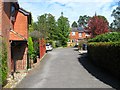
Scarps Side, The Street, Bolney
Located between Image to the south and Image to the north and a fairly new build. The former was originally known as Scarps. This is the northern end of The Street which ends at the gate beyond which continues the High Weald Landscape Trail.
Image: © Simon Carey
Taken: 25 Sep 2014
0.05 miles
4
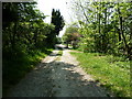
Footpath 3Bo leaving Top Street Bolney
The footpath is part of the High Weald Landscape Trial.
Image: © Dave Spicer
Taken: 23 Apr 2011
0.06 miles
5
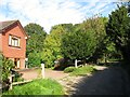
Scarps Meadow Cottages, The Street, Bolney
The northern most dwellings on the eastern side of The Street were built sometime in the 1970s.
Image: © Simon Carey
Taken: 25 Sep 2014
0.07 miles
6
Springfield Cottages, Top Street, Bolney
Two sets of four cottages straddles the western end of Top Street before its junction with The Street. They were built in the late 19th century.
Image: © Simon Carey
Taken: 25 Sep 2014
0.07 miles
7
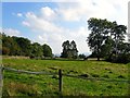
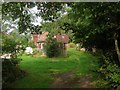
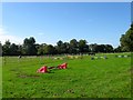
Barn Field (2)
The name of the field according to Bolney's 1842 tithe map and another view of Image this time looking south. The line of trees on the left mark the course of the old sunken lane heading south to Bolney.
Image: © Simon Carey
Taken: 19 Sep 2014
0.07 miles
8
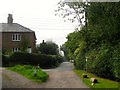
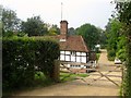
The Street, Bolney
Viewed at the point where the current road turns east into Top Street with Springhead Cottages to the left. After to enclosure of Bolney Common a track still headed north to Malthouse Farm but has now been reduced to the status of a footpath.
Image: © Simon Carey
Taken: 7 Sep 2014
0.08 miles
9
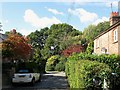
Springfield Close, Bolney
Built in 1988 on the site of the former village stores, see also Image The cul de sac is located off Top Street.
Image: © Simon Carey
Taken: 25 Sep 2014
0.08 miles
10
Home Field
The name of the field according to Bolney's 1842 tithe map that lies to the east of Image
Image: © Simon Carey
Taken: 25 Sep 2014
0.10 miles