IMAGES TAKEN NEAR TO
Staplefield Road, HAYWARDS HEATH, RH17 5JF
Introduction
This page details the photographs taken nearby to Staplefield Road, RH17 5JF by members of the Geograph project.
The Geograph project started in 2005 with the aim of publishing, organising and preserving representative images for every square kilometre of Great Britain, Ireland and the Isle of Man.

There are currently over 7.5m images from over14,400 individuals and you can help contribute to the project by visiting https://www.geograph.org.uk
Image Map
Images are licensed for reuse under creativecommons.org/licenses/by-sa/2.0
Notes
- Clicking on the map will re-center to the selected point.
- The higher the marker number, the further away the image location is from the centre of the postcode.
Image Listing (19 Images Found)
Images are licensed for reuse under creativecommons.org/licenses/by-sa/2.0
Image
Details
Distance
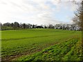
2
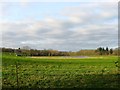
Ox Pasture/Hop Garden Field
The name of the fields according to Cuckfield's 1843 tithe map that have been merged along with Lower Warren to the south to form a larger unit with this section now landscaped in the last few years with a pond. Ox Pasture was in the foreground adjacent to the B2114 whilst Hop Garden Field was at the far end.
Image: © Simon Carey
Taken: 20 Dec 2014
0.10 miles
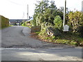
3
Bridleway leaving the Cuckfield Road
Heading eastwards on a Bridleway towards Cleaver’s Lane.
Image: © Chris Thomas-Atkin
Taken: 26 Mar 2018
0.11 miles
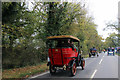
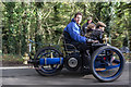
4
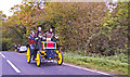
1899 Wagonette on B2114 during 2008 London to Brighton Veteran Car Run
Image: © Christine Matthews
Taken: 2 Nov 2008
0.12 miles
5
North Field/Great Ox Pasture
The name of the fields according to Cuckfield's 1843 tithe map that have been merged to form a larger unit, Great Ox Pasture occupied the eastern side in the foreground whilst North Field was to the west adjacent to the B2114 and containing the newly built barn at the top of the slope. To the east is Image whilst to the north is Image
Image: © Simon Carey
Taken: 20 Dec 2014
0.13 miles
6
2011 London to Brighton Veteran Car Run on B2114
Give way to the veterans on this one way section of the course.
Image: © Christine Matthews
Taken: 6 Nov 2011
0.13 miles
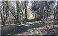
7
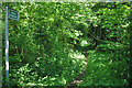
Obscure bridleway
With summer foliage and vegetation, the start of this bridleway is not obvious, the sign being set back a little from the road. Further on it is, or used to be, quite a broad way between its banks. Unfortunately it starts at a point on a fairly busy road rather a long way from any connection to other off-road routes. This no doubt accounts for its light use.
Image: © Robin Webster
Taken: 3 Jun 2010
0.14 miles
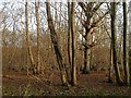
8
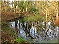
Pond, Furze Field
Occupying the south west corner of the wood next to the junction of Cleaver's Lane bridleway and Cuckfield Road, the B2114. It is marked on the 1874 OS map and its position near the highways suggest an old marlpit.
Image: © Simon Carey
Taken: 20 Dec 2014
0.15 miles
9
Veteran Car, Cuckfield Road, Sussex
This three wheeler was passing down the hill towards Cuckfield at a cracking speed.
Image: © Christine Matthews
Taken: 3 Nov 2013
0.15 miles
10
Furze Field
The name of the field according to Cuckfield's 1843 tithe map that is now a wood. Most fields with this name were often marginal agricultural land and a number would often end up becoming areas of woodland. Not to far from this spot was Holmsteadhill Turnpike gate erected to collect tolls from Cleaver's Lane to enter what was originally the first London-Brighton turnpike. To the east is Image and to the north is Image
Image: © Simon Carey
Taken: 20 Dec 2014
0.16 miles