IMAGES TAKEN NEAR TO
London Lane, HAYWARDS HEATH, RH17 5BD
Introduction
This page details the photographs taken nearby to London Lane, RH17 5BD by members of the Geograph project.
The Geograph project started in 2005 with the aim of publishing, organising and preserving representative images for every square kilometre of Great Britain, Ireland and the Isle of Man.

There are currently over 7.5m images from over14,400 individuals and you can help contribute to the project by visiting https://www.geograph.org.uk
Image Map
Images are licensed for reuse under creativecommons.org/licenses/by-sa/2.0
Notes
- Clicking on the map will re-center to the selected point.
- The higher the marker number, the further away the image location is from the centre of the postcode.
Image Listing (33 Images Found)
Images are licensed for reuse under creativecommons.org/licenses/by-sa/2.0
Image
Details
Distance
1
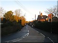
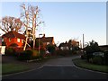
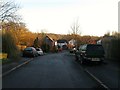
London Lane, Cuckfield
The B2184 that connects Broad Street with the B2036 next to the Rose & Crown public house. Much of the housing on the right was built in the first decade of the 20th century. A busy road that enables drivers to avoid the centre of Cuckfield.
Image: © Simon Carey
Taken: 17 Feb 2015
0.01 miles
2
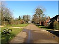
Hatchlands, Cuckfield
A small cul de sac off Broad Street that was developed in the 1980s in the grounds of a former Victorian townhouse of the same name. Unlike neighbouring Myttens the house was demolished.
Image: © Simon Carey
Taken: 17 Feb 2015
0.05 miles
3
Brick Lane, Cuckfield
A new development off Chatfield Road that was built around 2011 in a former field called Chatfield Plots according to Cuckfield's 1843 tithe map.
Image: © Simon Carey
Taken: 17 Feb 2015
0.08 miles
4
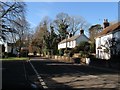
Cottages, Broad Street, Cuckfield
Located at the junction with Courtmead Road. To the right is Roseland Cottage with the semi-detached Morecroft and Greenwoods beyond whilst on the other side of the road at a right angle to it is Perryfields. All the cottages date from at least the 19th century.
Image: © Simon Carey
Taken: 17 Feb 2015
0.08 miles
5
Mytten Close, Cuckfield
This section of Mytten Close was built in the 1960s in the grounds of a large house called Myttens which still stands but is now surrounded by the estate. According to Cuckfield's 1843 tithe map this was once a field called Bull Field.
Image: © Simon Carey
Taken: 17 Feb 2015
0.10 miles
6
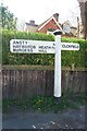
Old Direction Sign - Signpost by the B2184, Broad Street, Cuckfield parish
Black iron cap finial - 2 arms; East Sussex wood by the UC road, in parish of Cuckfield (Mid Sussex District), B2184 Broad Street, against fence and hedge at back of pavement, opposite junction of London Lane with Broad Street.
Surveyed
Milestone Society National ID: SX_TQ3024
Image: © Milestone Society
Taken: Unknown
0.10 miles
7
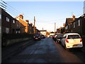
Chatfield Road, Cuckfield
A residential road that links London Lane to Horsgate Lane that was developed just before the First World War with later infilling.
Image: © Simon Carey
Taken: 17 Feb 2015
0.12 miles
8
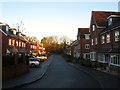
Mytten Close, Cuckfield
This is a western extension of the cul de sac added in the mid 1970s in the former grounds of Mytten House which still exists behind the fence to the left.
Image: © Simon Carey
Taken: 20 Dec 2014
0.14 miles
9
The Brambles, Cuckfield
A cul de sac off Image that was built in the 1990s on the old site of Cuckfield gas works.
Image: © Simon Carey
Taken: 17 Feb 2015
0.14 miles
10
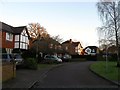
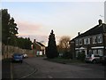
Courtmead Road, Cuckfield
A private estate designed in the 1930s by local architect Harold Turner with the straight access road following the course of an old public right of way which still remains a public footpath today. The houses to the south were the first to be developed and occupy a couple of former fields called Court Meadow and Stone Rocks. Those to the north were gradually built from the end of the Second World War and completed in the 1970s.
Image: © Simon Carey
Taken: 17 Feb 2015
0.14 miles