IMAGES TAKEN NEAR TO
Burgess Hill Road, HAYWARDS HEATH, RH17 5AH
Introduction
This page details the photographs taken nearby to Burgess Hill Road, RH17 5AH by members of the Geograph project.
The Geograph project started in 2005 with the aim of publishing, organising and preserving representative images for every square kilometre of Great Britain, Ireland and the Isle of Man.

There are currently over 7.5m images from over14,400 individuals and you can help contribute to the project by visiting https://www.geograph.org.uk
Image Map
Images are licensed for reuse under creativecommons.org/licenses/by-sa/2.0
Notes
- Clicking on the map will re-center to the selected point.
- The higher the marker number, the further away the image location is from the centre of the postcode.
Image Listing (21 Images Found)
Images are licensed for reuse under creativecommons.org/licenses/by-sa/2.0
Image
Details
Distance
1
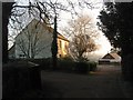
Harvest Hill Cottages
Dating from the late 19th century and located to the immediate north of the house called Harvest Hill. The drive is also a bridleway which winds its way to Copyhold Lane.
Image: © Simon Carey
Taken: 30 Dec 2014
0.04 miles
2
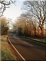
Harvest Hill
The name of the B2036 between the junction with Cuckfield road at the southern end of Ansty and the entrance to Moonhill Place after which it becomes Pains Flat. To the west is Image whilst to the east is Image
Image: © Simon Carey
Taken: 30 Dec 2014
0.05 miles
3
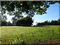
Front Meadow
The name of the field according to Cuckfield's 1842 tithe map that lies to the east of the house called Harvest Hill and south of Image Viewed from the bridleway that links the road called Harvest Hill with Copyhold Lane near Haywards Heath.
Image: © Simon Carey
Taken: 5 Oct 2014
0.06 miles
4
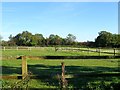
Barn Mead
The name of the field according to Cuckfield's 1842 tithe map that is bounded by Harvest Hill, the B2036, to the west, Image to the south and Image to the east. Now subdivided into a number of paddocks.
Image: © Simon Carey
Taken: 5 Oct 2014
0.06 miles
5

Harvest Hill
The B2036 heading north to Ansty from Burgess Hill. From the 1770s it was the main London-Brighton turnpike until superseded by more direct routes.
Image: © Simon Carey
Taken: 5 Oct 2014
0.07 miles
6

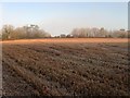
Barn Field (2)
Another view of Image with out the view restricting maize crop in place when I last visited in autumn. The view thus shows how the field has been extended to include Image to the south, the two lone oaks being the remnant of the former field boundary. The tree tops of Kiln Wood is visible through the early morning mist.
Image: © Simon Carey
Taken: 30 Dec 2014
0.09 miles
7
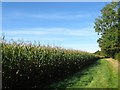
Barn Field (1)
The name of the field according to Cuckfield's 1842 tithe map that has been merged with Image to the west to form a larger unit. To the east is Harvest Hill, the B2036. See Image for a view with the maize crop removed.
Image: © Simon Carey
Taken: 5 Oct 2014
0.11 miles
8
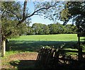
Five Acres
The name of the field according to Cuckfield's 1843 tithe map that is bounded by Image to the south and Image to the west.
Image: © Simon Carey
Taken: 30 Dec 2014
0.11 miles
9
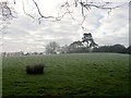
Calf Field/Barn Field
The name of the fields according to Cuckfield's 1843 tithe map that have been merged along with Image to the east to form a larger unit. Calf Field was in the foreground near the foot of the slope whilst Barn Field was further up and once contained a barn next to the trees at top to the right known as Harvest Hill Barn.
Image: © Simon Carey
Taken: 30 Dec 2014
0.11 miles
10
Pookridge Pasture
The name of the field according to Cuckfield's 1842 tithe map that is bounded by Image to the west, Image beyond the bridleway to the east and Image to the north.
Image: © Simon Carey
Taken: 5 Oct 2014
0.16 miles