IMAGES TAKEN NEAR TO
The Fairways, REDHILL, RH1 6LP
Introduction
This page details the photographs taken nearby to The Fairways, RH1 6LP by members of the Geograph project.
The Geograph project started in 2005 with the aim of publishing, organising and preserving representative images for every square kilometre of Great Britain, Ireland and the Isle of Man.

There are currently over 7.5m images from over14,400 individuals and you can help contribute to the project by visiting https://www.geograph.org.uk
Image Map
Images are licensed for reuse under creativecommons.org/licenses/by-sa/2.0
Notes
- Clicking on the map will re-center to the selected point.
- The higher the marker number, the further away the image location is from the centre of the postcode.
Image Listing (99 Images Found)
Images are licensed for reuse under creativecommons.org/licenses/by-sa/2.0
Image
Details
Distance
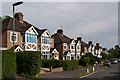
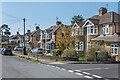
1

The Fairways
Cul-de-sac off Somerset Road, built in c.1998 on the site of four early 20th Century houses, Greenside, Meadhurst, Hill End and Ardmore.
Image: © Ian Capper
Taken: 19 Apr 2021
0.01 miles
2

The Fairways
Cul-de-sac off Somerset Road, built in c.1998 on the site of four early 20th Century houses, Greenside, Meadhurst, Hill End and Ardmore.
Image: © Ian Capper
Taken: 19 Apr 2021
0.01 miles
3

The Fairways
Cul-de-sac off Somerset Road, built in c.1998 on the site of four early 20th Century houses, Greenside, Meadhurst, Hill End and Ardmore.
Image: © Ian Capper
Taken: 19 Apr 2021
0.03 miles
4
Clarence Walk
1930s extension of a 19th century stub (see Image).
Image: © Ian Capper
Taken: 5 Jul 2012
0.06 miles
5
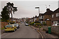
Clarence Walk
1930s housing south of Meadvale. Although the style of housing on either side of the road appears to be similar, a 1935 map shows only the right hand side to have been developed at that time.
Image: © Ian Capper
Taken: 13 Apr 2012
0.06 miles
6

Rosemead Close
Cul-de-sac of maisonettes off Somerset Road/Cronks Hill Road, built in the c.1950s/60s on part of the grounds of a late Victorian house named "The Old Rosery" (since demolished). Adjacent to it is Greenmead Cottage (see Image), so perhaps the name of the close was a deliberate combination of part of each name.
Image: © Ian Capper
Taken: 19 Apr 2021
0.07 miles
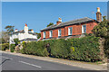
7
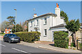
Greenmead Cottage
19th Century villa on Somerset Road. Grade II listed - see www.historicengland.org.uk/listing/the-list/list-entry/1029070.
Image: © Ian Capper
Taken: 19 Apr 2021
0.07 miles
8
Clarence Walk
Old maps suggest that this house predates the development of Clarence Walk for housing in the 1930s, when Clarence Walk itself was only a footpath, of which the stretch seen in this photo, linking the present day cul de sac with Pendleton Road, is a remnant.
Image: © Ian Capper
Taken: 13 Apr 2012
0.07 miles
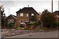
9
Clarence Walk
1930s extension of a 19th century stub off Somerset Road.
Image: © Ian Capper
Taken: 19 Apr 2021
0.08 miles
10
Greenmead Cottage and The Mount
Two 19th Century villas on Somerset Road, with Greenmead Cottage on the left and The Mount on the right. Both are grade II listed - see www.historicengland.org.uk/listing/the-list/list-entry/1029070 and www.historicengland.org.uk/listing/the-list/list-entry/1189084 respectively.
Image: © Ian Capper
Taken: 19 Apr 2021
0.08 miles