1
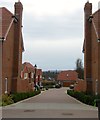
Chapel Heights, Bolnore Road, Haywards Heath
The former chapel was converted into flats in 2001 and having once been the place of worship for the community of the Holy Cross convent which moved to Haywards Heath in 1886 and left in 1979. The former nunnery known as Grosvenor Hall was converted into offices in 1980 and has been occupied by the charity Sightsavers since 1990 though they too are due to move and have sold the building so it can be converted into housing.
The former convert occupied the northern end of Reading Wood part of which still survives to the south and contains a burial area for the former nuns.
Image: © Simon Carey
Taken: 30 Mar 2015
0.03 miles
2
Shire Lane, Haywards Heath
Once part of a field called Upper meadow according to Cuckfield's 1843 tithe map, this small cul de sac off Bolnore Road was built in the last couple of years. The South Downs can be seen in the distance.
Image: © Simon Carey
Taken: 30 Mar 2015
0.07 miles
3
Birch Cottage, Bolnore Farm Lane, Haywards Heath
Located opposite
Image and originally built as a lodge in the late 19th century for the Convent of the Holy Cross. The lodge was later subdivided into two dwellings St Stephens Cottage, partially obscured to the right, and Birch Cottage which was previously known as Holy Cross Cottage.
Image: © Simon Carey
Taken: 12 Apr 2015
0.08 miles
4
St Catherine's Cottage, Bolnore Farm Lane, Haywards Heath
Built in the first decade of the 20th century at a former entrance of the Convent of the Holy Cross. The track from Isaac's Lane ends at this point though the bridleway continues southwards to the right.
Image: © Simon Carey
Taken: 30 Mar 2015
0.08 miles
5
Saddlers Way, Bolnore Village
The new road will be the access route for the last phase of the Bolnore village development. This section occupies a former field called Crabtree Field, according to Cuckfield's 1843 tithe map.
Image: © Simon Carey
Taken: 30 Mar 2015
0.09 miles
6
Lower Meadow, Beech Hurst Gardens, Haywards Heath
Part of the large recreation ground and found between Bolnore road to the south and the miniature railway to the north.
Image: © Simon Carey
Taken: 7 Apr 2015
0.10 miles
7
Kickabout Area, Beech Hurst Gardens, Haywards Heath
In the south west corner of the park that was acquired by the local council in the early 1950s and is now a popular recreational area. Once the southern part of Whitegate Field according to Cuckfield's 1843 tithe map, the northern portion now containing
Image It later became part of a neighbouring nursery before being added to the park.
Image: © Simon Carey
Taken: 30 Mar 2015
0.10 miles
8
Bolnore Farm Cottage, Bolnore Farm Lane, Haywards Heath
Viewed from the footpath that runs from Bolnore Farm Lane to Parkfield Way. The cottage dates from the Victorian period and is now overlooked by the new Bolnore village development.
Image: © Simon Carey
Taken: 31 Mar 2015
0.10 miles
9
Bolnore Farm Lane, Haywards Heath
The current track heads south from Isaac's Lane to Bolnore Farm, whose buildings can be seen on the left, and a couple of cottages. The track itself is much older being marked on a 1638 estate map and called Half Street Lane.
Image: © Simon Carey
Taken: 30 Mar 2015
0.11 miles
10
Ashton House, Bolnore Road, Haywards Heath
Built in the late 19th century on a former field called Upper Riddens Wood Field according to Cuckfield's 1843 tithe map and originally called Longrove. By the 1910 OS map it had become St Helena's Convalescent Home and remained so until around Second World War. By the 1950s it had become a guest house for the neighbouring Convent of the Holy Cross and was probably sold when the nuns moved to Loughborough in 1979. It is now a nursing home.
Image: © Simon Carey
Taken: 30 Mar 2015
0.12 miles


