IMAGES TAKEN NEAR TO
Woodstock Place, HAYWARDS HEATH, RH16 3UJ
Introduction
This page details the photographs taken nearby to Woodstock Place, RH16 3UJ by members of the Geograph project.
The Geograph project started in 2005 with the aim of publishing, organising and preserving representative images for every square kilometre of Great Britain, Ireland and the Isle of Man.

There are currently over 7.5m images from over14,400 individuals and you can help contribute to the project by visiting https://www.geograph.org.uk
Image Map
Images are licensed for reuse under creativecommons.org/licenses/by-sa/2.0
Notes
- Clicking on the map will re-center to the selected point.
- The higher the marker number, the further away the image location is from the centre of the postcode.
Image Listing (65 Images Found)
Images are licensed for reuse under creativecommons.org/licenses/by-sa/2.0
Image
Details
Distance
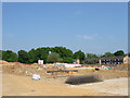
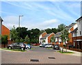
1
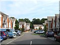
Woodstock Place, Haywards Heath
Part of the new development on the old Wilmington Way estate. The current road follows the course of the old one. Beyond is the Scrase Valley Nature Reserve.
Originally an open field called Furze Field on Lindfield's 1845 tithe map that was transferred to Haywards Heath during the 1930s. To the north is what is now the Scrase Valley Nature Reserve, to the south was the original course of America Lane, see Image, whilst to the west was Bent's Wood. During the Second World War the field was turned into allotments and after the conflict the southern end adjacent to the lane was developed with prefabs. This remained the case until the end of the 1960s when a new estate was built. Wilmington Way was another temporary measure designed to last twenty years but ending up being in place for nearly forty, the exception being a set of flats at the northern end that have remained. In 2008 a decision was taken to demolish the estate and rebuild again with the new estate roughly following the old road routes as well as a green strip that has been retained running north-south through the estate.
For the former Wilmington Way, taken in 2007, see:
Image
Image
Image
For the site after demolition, taken in 2011, see:
Image
Image
Image
For the current estate, taken in 2015, see:
Image
Image
Image
Image
Image
Image: © Simon Carey
Taken: 15 Aug 2015
0.01 miles
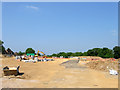
2
Redeveloping Wilmington Way (1)
Viewed through the gate on Hanbury Lane. The area was an open field until after the Second World War when a series of prefabs was constructed on the northern side of the lane. This lasted until the late 1960s when the council built Wilmington Way as a stopgap measure to ease the housing crisis. These houses were also prefabricated and designed to last twenty years though in the end they hung around for over forty. A total of 185 new homes and flats will be built on the site with the estate to be renamed expunging Wilmington Way to history.
See Image, Image and Image for an old view.
For an updated view taken four years on, see:
Image
Image
Image
Image
Image
Image
Image: © Simon Carey
Taken: 30 Apr 2011
0.02 miles
3
Playground, Wilmington Way
I used to play in this playground when I was 5 or 6 and I swear most of the equipment in there is the same today, particularly vivid memories of the snail and train. I'd imagine the playground was placed there when the estate was built circa 1970. The only change I think is the fence that has been added.
Image: © Simon Carey
Taken: 30 Aug 2007
0.04 miles
4
Wilmington Way
Council estate built around 1970 on the eastern side of town. The terraces are interspersed with green areas and paths linking the rows. A local cat keeps an eye on my activities.
Image: © Simon Carey
Taken: 30 Aug 2007
0.04 miles
5
Redeveloping Wilmington Way (3)
Viewed through the gate on Haylind Road. The area was an open field until after the Second World War when a series of prefabs was constructed on the northern side of the lane. This lasted until the late 1960s when the council built Wilmington Way as a stopgap measure to ease the housing crisis. These houses were also prefabricated and designed to last twenty years though in the end they hung around for over forty. A total of 185 new homes and flats will be built on the site with the estate to be renamed expunging Wilmington Way to history. The flats on the right are Image the only surviving buildings from the estate whilst the trees beyond mark the location of Scrase Valley Nature Reserve.
See Image, Image and Image for an old view.
For updated views taken four years later, see:
Image
Image
Image
Image
Image
Image
Image: © Simon Carey
Taken: 30 Apr 2011
0.04 miles
6
Wilmington Way
At the end of a footpath from Hanbury Lane to a small car park next to the playground. The abandoned football boots draped over the telephone line gives the image an interesting border.
Image: © Simon Carey
Taken: 30 Aug 2007
0.04 miles
7
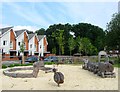
Play Area, Woodstock Place, Haywards Heath
My inner five year old is pleased to see a snail and train as part of the play area, a nod to the old equipment that served the previous estate for forty years. The play area is located between Woodtsock Place and Plymouth Way.
Originally an open field called Furze Field on Lindfield's 1845 tithe map that was transferred to Haywards Heath during the 1930s. To the north is what is now the Scrase Valley Nature Reserve, to the south was the original course of America Lane, see Image, whilst to the west was Bent's Wood. During the Second World War the field was turned into allotments and after the conflict the southern end adjacent to the lane was developed with prefabs. This remained the case until the end of the 1960s when a new estate was built. Wilmington Way was another temporary measure designed to last twenty years but ending up being in place for nearly forty, the exception being a set of flats at the northern end that have remained. In 2008 a decision was taken to demolish the estate and rebuild again with the new estate roughly following the old road routes as well as a green strip that has been retained running north-south through the estate.
For the former Wilmington Way, taken in 2007, see:
Image
Image
Image
For the site after demolition, taken in 2011, see:
Image
Image
Image
For the current estate, taken in 2015, see:
Image
Image
Image
Image
Image
Image: © Simon Carey
Taken: 15 Aug 2015
0.05 miles
8
Redeveloping Wilmington Way (2)
Viewed through the gate on Haylind Road. The area was an open field until after the Second World War when a series of prefabs was constructed on the northern side of the lane. This lasted until the late 1960s when the council built Wilmington Way as a stopgap measure to ease the housing crisis. These houses were also prefabricated and designed to last twenty years though in the end they hung around for over forty. A total of 185 new homes and flats will be built on the site with the estate to be renamed expunging Wilmington Way to history. The houses on the left are on Hanbury Lane whilst the trees to the right mark the location of Scrase Valley Nature Reserve.
See Image, Image and Image for an old view.
For an updated views taken four years later, see:
Image
Image
Image
Image
Image
Image
Image: © Simon Carey
Taken: 30 Apr 2011
0.05 miles
9
Portland Close, Haywards Heath
A small cul de sac off Woodstock Place and part of a new development completed in 2013 on the site of a former council estate called Wilmington Way. The close has been built on an area that previously was a car park and open play space.
Originally an open field called Furze Field on Lindfield's 1845 tithe map that was transferred to Haywards Heath during the 1930s. To the north is what is now the Scrase Valley Nature Reserve, to the south was the original course of America Lane, see Image, whilst to the west was Bent's Wood. During the Second World War the field was turned into allotments and after the conflict the southern end adjacent to the lane was developed with prefabs. This remained the case until the end of the 1960s when a new estate was built. Wilmington Way was another temporary measure designed to last twenty years but ending up being in place for nearly forty, the exception being a set of flats at the northern end that have remained. In 2008 a decision was taken to demolish the estate and rebuild again with the new estate roughly following the old road routes as well as a green strip that has been retained running north-south through the estate.
For the former Wilmngton Way, taken in 2007, see:
Image
Image
Image
For the site after demolition, taken in 2011, see:
Image
Image
Image
For the current estate, taken in 2015, see:
Image
Image
Image
Image
Image
Image
Image: © Simon Carey
Taken: 15 Aug 2015
0.05 miles
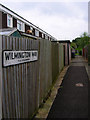
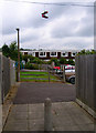
10
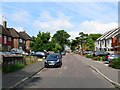
Hanbury Lane, Haywards Heath
Once the original course of America Lane which left Gravelye Lane in the east ran down the hill across the unnamed stream then followed this direction until turning south down what is now Barn Cottage Lane then west again along America Lane to the small hamlet of America. The latter was set up in the 1820s by William Allen as a small settlement of self sufficient smallholders who were given a cottage and a plot of land. Allen was an industrialist who ran a pharmaceutical company that later became Allen & Hanbury which was swallowed up by Glaxo in 1958 and whose name only disappeared from products in 2013.
To the right are new houses built on the old Wilmington Way estate, see Image, for a view during redevelopment.
Image: © Simon Carey
Taken: 15 Aug 2015
0.06 miles