IMAGES TAKEN NEAR TO
Woodlands Road, HAYWARDS HEATH, RH16 3JY
Introduction
This page details the photographs taken nearby to Woodlands Road, RH16 3JY by members of the Geograph project.
The Geograph project started in 2005 with the aim of publishing, organising and preserving representative images for every square kilometre of Great Britain, Ireland and the Isle of Man.

There are currently over 7.5m images from over14,400 individuals and you can help contribute to the project by visiting https://www.geograph.org.uk
Image Map
Images are licensed for reuse under creativecommons.org/licenses/by-sa/2.0
Notes
- Clicking on the map will re-center to the selected point.
- The higher the marker number, the further away the image location is from the centre of the postcode.
Image Listing (48 Images Found)
Images are licensed for reuse under creativecommons.org/licenses/by-sa/2.0
Image
Details
Distance
1
Fields End Close, Haywards Heath
A cul de sac that continues from the western end of Woodlands Road that was built in the 1980s.
Image: © Simon Carey
Taken: 7 Apr 2015
0.05 miles
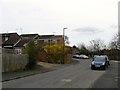
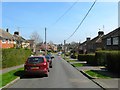
2
Mayflower Road, Haywards Heath
A residential road that runs between New England Road and Woodlands Road and built by the council in 1925.
Image: © Simon Carey
Taken: 30 Mar 2015
0.05 miles
3
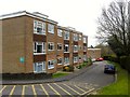
Mayflower Court, Haywards Heath
Small cul de sac containing a couple of blocks of flats that were constructed in the mid 1960s on the site of a former corporation yard.
Image: © Simon Carey
Taken: 30 Mar 2015
0.07 miles
4
Pineham Copse, Haywards Heath
A cul de sac of St Augustine's Way. Marked as Red Lion Wood on Cuckfield's 1843 tithe map, it was designated part of Petland Wood by the 1874 OS map and survived up until the end of the 1970s as part of the extensive grounds belonging to the Priory.
Image: © Simon Carey
Taken: 30 Mar 2015
0.08 miles
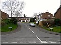
5
New England Road Haywards Heath
Heyworth Primary School is on the left.
Image: © Dave Spicer
Taken: 7 Sep 2012
0.08 miles
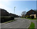
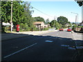
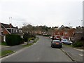
6
Woodlands Road, Haywards Heath
Looking eastwards from the junction with Mayflower Road, the initial three houses on either side date from the 1920s when the road was originally laid out, those beyond were added in the late 1950s when the road was extended to Windermere Road. Prior to that much of the area was the original site of Haywards Heath's first sewage farm which by 1910 has become allotments. The eastern end of the road is built on the site of a former brick field. The woodlands in the name would have been an acknowledgement of nearby Petlands Wood and Bent's Wood both of which have been lost to development.
Image: © Simon Carey
Taken: 7 Apr 2015
0.08 miles
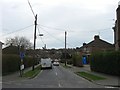
7
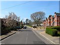
New England Road, Haywards Heath
The current road runs from Hazelgrove road to the eastern junction with Bentswood Road where it becomes America Lane. Prior to the 18890s it was little more than a track which would be straightened and gradually developed, the houses on the right were built during the Edwardian period and larger than some of the victorian cottages further east. Beyond them is Warden Park Primary Academy.
Image: © Simon Carey
Taken: 7 Apr 2015
0.09 miles
8
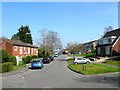
Priory Way, Haywards Heath
Viewed from the junction with St Augustine's Way, the road heads north to its junction with Western Road. Much of the estate was built in the late 1970s in the grounds of the former Priory of Our Lady.
Image: © Simon Carey
Taken: 7 Apr 2015
0.09 miles
9
Priory Way, Haywards Heath
Once part of Petland Wood which covered an area now containing Haywards Heath cemetery, Western Road, Eastern Road, North Road and Victoria Road. This part remained undeveloped until the 1970s when this estate was built which was later extended southwards into the former grounds of the Priory.
Image: © Simon Carey
Taken: 30 Mar 2015
0.09 miles
10
Rothley Chase, Haywards Heath
A small cul de sac off Priory Way that was once part of Petland Wood and was not developed until the late 1970s as part of the former grounds of the Priory.
Image: © Simon Carey
Taken: 30 Mar 2015
0.10 miles