IMAGES TAKEN NEAR TO
Gravelye Lane, HAYWARDS HEATH, RH16 2RX
Introduction
This page details the photographs taken nearby to Gravelye Lane, RH16 2RX by members of the Geograph project.
The Geograph project started in 2005 with the aim of publishing, organising and preserving representative images for every square kilometre of Great Britain, Ireland and the Isle of Man.

There are currently over 7.5m images from over14,400 individuals and you can help contribute to the project by visiting https://www.geograph.org.uk
Image Map
Images are licensed for reuse under creativecommons.org/licenses/by-sa/2.0
Notes
- Clicking on the map will re-center to the selected point.
- The higher the marker number, the further away the image location is from the centre of the postcode.
Image Listing (36 Images Found)
Images are licensed for reuse under creativecommons.org/licenses/by-sa/2.0
Image
Details
Distance
1
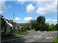
Greyfriars, Gravelye Lane, Lindfield
The first building reached when heading into Lindfield from the east on the junction of Lewes Road and Gravelye lane which dates from 1830 and is a former tollhouse. By the 1875 OS map it was known as Spire Cottage acquiring its current name sometime in the late 1950s.
Image: © Simon Carey
Taken: 15 Aug 2015
0.00 miles
2
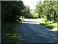
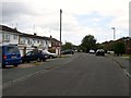
Gravelye Lane junction with the B2111 near Walstead
Image: © Dave Spicer
Taken: 7 Sep 2012
0.01 miles
3
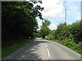
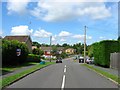
Scamps Hill
The B2111 as it drops down towards the eastern end of Lindfield.
Image: © Simon Carey
Taken: 15 Aug 2015
0.02 miles
4
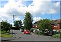
Kidbrook, Lindfield
Small cul de sac off Image that was developed in the early 1970s and named after a nearby field Kidbrook Croft which lay on the western side of Scrase Stream.
Image: © Simon Carey
Taken: 15 Aug 2015
0.04 miles
5
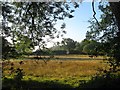
Apps Meadow
The name of the field according to Lindfield's 1845 tithe map that is bounded by Scrase Stream to the west and Lewes road, the B2111, to the south.
Image: © Simon Carey
Taken: 9 Aug 2015
0.04 miles
6
Meadow Drive, Lindfield
The road heads west from Gravelye Lane then turns south having crossed Scrase Stream, see Image Developed in the early 1970s on the site of a former laundry, see Image, for more details. The turning on the right is Image
Image: © Simon Carey
Taken: 15 Aug 2015
0.07 miles
7
Grey Alders, Lindfield
A cul de sac off Image that was developed in the early 1970s on the site of the former Mid Sussex Steam Laundry. The laundry was opened as a charitable concern in 1902 to provide work for women in difficult circumstances. It was taken over by the Salvation Army in 1912 and was ran as a business concern from 1922 until its closure in 1972. All buildings were demolished leaving no trace. See http://www.williamallenquaker.co.uk/Laundry.gif for an undated aerial view.
Image: © Simon Carey
Taken: 15 Aug 2015
0.08 miles
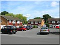
8
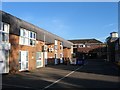
Lindfield Enterprise Park, Lewes Road, Lindfield
Built on the site of a former postwar garage. The building on the right is The Clock Tower, home, since 2013, to Lindfield parish council.
Image: © Simon Carey
Taken: 9 Aug 2015
0.09 miles
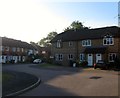
9
Meadow Drive, Lindfield
A cul de sac off Gravelye Lane with this section developed in the late 1960s on a former meadow adjacent to Scrase Stream.
Image: © Simon Carey
Taken: 4 Aug 2015
0.11 miles
10
East Wick, Lindfield
Small cul de sac off Noah's Ark Lane built in 1990 on the site of an old yard which was formerly part of a field called The East Wick according to Lindfield's 1845 tithe map.
Image: © Simon Carey
Taken: 9 Aug 2015
0.11 miles