IMAGES TAKEN NEAR TO
Lark Rise Close, HAYWARDS HEATH, RH16 2QW
Introduction
This page details the photographs taken nearby to Lark Rise Close, RH16 2QW by members of the Geograph project.
The Geograph project started in 2005 with the aim of publishing, organising and preserving representative images for every square kilometre of Great Britain, Ireland and the Isle of Man.

There are currently over 7.5m images from over14,400 individuals and you can help contribute to the project by visiting https://www.geograph.org.uk
Image Map
Images are licensed for reuse under creativecommons.org/licenses/by-sa/2.0
Notes
- Clicking on the map will re-center to the selected point.
- The higher the marker number, the further away the image location is from the centre of the postcode.
Image Listing (38 Images Found)
Images are licensed for reuse under creativecommons.org/licenses/by-sa/2.0
Image
Details
Distance
1
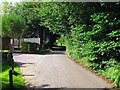
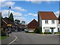
Lyoth Lane, Lindfield
An old country lane linking Gravelye Lane to Snowdrop Lane on the former Lyoth Common. The western end has now been engulfed by the growth of suburbia with the development of a new estate beyond the trees to the right, see Image
Image: © Simon Carey
Taken: 6 Sep 2015
0.05 miles
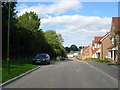
2
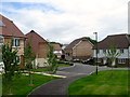
Speedwell Drive, Lindfield
Part of the new Heathwood estate being built by Barratt homes. The path in the foreground links the estate to Lyoth Lane, vehicular access is via Langmore Lane. Originally an open field that was unnamed on Lindfield's 1845 tithe map but contained Jordans Barn up to at least the First World War.
Image: © Simon Carey
Taken: 4 Aug 2015
0.07 miles
3
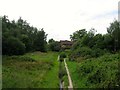
Northlands Brook
A tributary of Scrase Stream that has been straightened and culverted since the building of the Northlands Wood estate. The houses at the far end are on Beech Hill in Franklands Village now part of Haywards Heath.
Image: © Simon Carey
Taken: 4 Aug 2015
0.07 miles
4
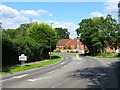
Gravelye Lane, Lindfield
An old lane that originally ran south from Lewes Road then through Franklands Wood to the former Franklands Farm at Birch Green. Much of the latter now lies beneath suburban Haywards Heath whilst the road now becomes Northlands Avenue over the parish boundary its former route through the 1930s Franklands Village now closed to traffic from the north. The two road junctions on the right are Lyoth Lane, an old country lane that runs east to Lyoth Common, and Langmore Lane, a new development recently completed.
Image: © Simon Carey
Taken: 6 Sep 2015
0.09 miles
5
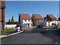
New development off Gravelye Lane Haywards Heath
Previously a grass field on the eastern outskirts of the town.
Image: © Dave Spicer
Taken: 7 Sep 2012
0.10 miles
6
Holbeck Walk, Lindfield
A residential road that runs in arc between various points of Chilton Grove built in 2012.
Image: © Simon Carey
Taken: 6 Sep 2015
0.10 miles
7
Cowslip Drive, Lindfield
Part of the new Heathwood Park estate currently being developed on the south eastern side of the village. Originally a field called Five Acres according to Lindfield's 1845 tithe map the former tree lined field boundary still remains on the left containing a public footpath that links Lyoth lane to Gravelye Lane.
Image: © Simon Carey
Taken: 6 Sep 2015
0.11 miles
8
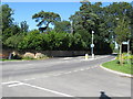
Bridleway sign on Gravelye Lane
The bridleway travels a short distance to The Hollows.
Image: © Dave Spicer
Taken: 7 Sep 2012
0.11 miles
9
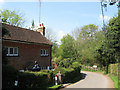
The Old Cottage, Lyoth Lane
Looks like an 18th century cottage on the bend of Lyoth Lane.
Image: © Simon Carey
Taken: 20 Apr 2011
0.11 miles
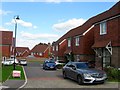
10
Langmore Lane, Haywards Heath
A new development built in 2012 off Gravelye Lane. The road will also be used as access for the new Heathwood park development currently being built in 2015.
Image: © Simon Carey
Taken: 6 Sep 2015
0.12 miles