IMAGES TAKEN NEAR TO
Bedales Hill, HAYWARDS HEATH, RH16 2QF
Introduction
This page details the photographs taken nearby to Bedales Hill, RH16 2QF by members of the Geograph project.
The Geograph project started in 2005 with the aim of publishing, organising and preserving representative images for every square kilometre of Great Britain, Ireland and the Isle of Man.

There are currently over 7.5m images from over14,400 individuals and you can help contribute to the project by visiting https://www.geograph.org.uk
Image Map
Images are licensed for reuse under creativecommons.org/licenses/by-sa/2.0
Notes
- Clicking on the map will re-center to the selected point.
- The higher the marker number, the further away the image location is from the centre of the postcode.
Image Listing (14 Images Found)
Images are licensed for reuse under creativecommons.org/licenses/by-sa/2.0
Image
Details
Distance
1
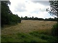
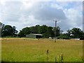
Park Field
The name of the field according to Lindfield's 1845 tithe map that is located to the west of Bedales Hill, the B2111. Originally a cottage existed in the foreground up to and including the 1910 OS map but disappears thereafter.
Image: © Simon Carey
Taken: 4 Aug 2015
0.06 miles
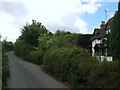
2
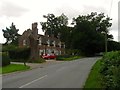
Walstead Manor Cottages, Scaynes Hill Road
A pair of semi-detached cottages were built here in the late 19th century but these appear to have been rebuilt between the wars. Located at the junction with Snowdrop Lane.
Image: © Simon Carey
Taken: 4 Aug 2015
0.09 miles
3
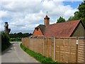
The Lodge, Scaynes Hill Road
Built in the first decade of the 20th century as the lodge to Walstead Manor located in the depths of Image
Image: © Simon Carey
Taken: 4 Aug 2015
0.11 miles
4
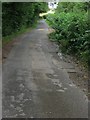
Snowdrop Lane
A narrow single lane highway that runs from the B2111 to the A272. Up to the 1960s it was marked on maps as Sluts Lane.
Image: © Simon Carey
Taken: 4 Aug 2015
0.11 miles
5
Site of Home Copse
On Lindfield's 1845 tithe map Home Copse extended up to the road from Image However, only a small square wood remains, see Image, with the northern part renamed, see Image, and this section completely grubbed by the time of the 1875 OS map. Now part of Renkum Stud Farm.
Image: © Simon Carey
Taken: 4 Aug 2015
0.13 miles
6
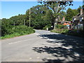
Snowdrop Lane meets Bedales Hill
Near Walstead Manor.
Image: © Dave Spicer
Taken: 7 Sep 2012
0.13 miles
7
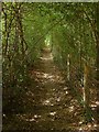
Footpath to Scaynes Hill Road
Squeezed between Image to the south and Image to the north as well as the grounds of Walstead Manor.
Image: © Simon Carey
Taken: 4 Aug 2015
0.17 miles
8
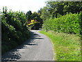
West along Snowdrop lane towards the Snowdrop Inn
The house entrance is to Snowdrop cottage.
Image: © Dave Spicer
Taken: 7 Sep 2012
0.17 miles
9
Snowdrop Cottage, Snowdrop Lane
Parts of the cottage date back to the 16th century but has been much altered. Snowdrop Lane was originally known as Sluts Lane until as late as the 1960s.
Image: © Simon Carey
Taken: 4 Aug 2015
0.19 miles
10
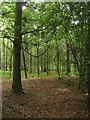
Home Copse
A small square tract of woodland that is the sole remnant of a much larger wood marked on Lindfield's 1845 tithe map, see Image and Image
Image: © Simon Carey
Taken: 4 Aug 2015
0.21 miles