IMAGES TAKEN NEAR TO
Yarrow Gate, HAYWARDS HEATH, RH16 2GB
Introduction
This page details the photographs taken nearby to Yarrow Gate, RH16 2GB by members of the Geograph project.
The Geograph project started in 2005 with the aim of publishing, organising and preserving representative images for every square kilometre of Great Britain, Ireland and the Isle of Man.

There are currently over 7.5m images from over14,400 individuals and you can help contribute to the project by visiting https://www.geograph.org.uk
Image Map
Images are licensed for reuse under creativecommons.org/licenses/by-sa/2.0
Notes
- Clicking on the map will re-center to the selected point.
- The higher the marker number, the further away the image location is from the centre of the postcode.
Image Listing (22 Images Found)
Images are licensed for reuse under creativecommons.org/licenses/by-sa/2.0
Image
Details
Distance
1
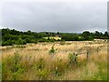
Three Acres
The name of the field according to Lindfield's 1845 tithe map which will soon be developed as part of the Heathwood estate like neighbouring Image to the south. The field was formerly part of Criplands Court Farm.
Image: © Simon Carey
Taken: 4 Aug 2015
0.08 miles
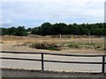
2
Ten Acres
The name of the field according to Lindfield's 1845 tithe map that lies to the north of Image and is currently awaiting development as it is part of a new development proposed by Wates.
Image: © Simon Carey
Taken: 15 Aug 2015
0.10 miles
3
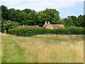
Criplands, Graveleye Lane, Lindfield
The house dates from the 17th century and was once the parish pest house used to house those with infectious diseases away from the main area of settlement. Was called Pest House on Lindfield's 1845 tithe map, Pesthouse Farm on the 1875 OS map, Cripland Court Farm on the 1910 edition and just Criplands from the 1960s onwards. Its former isolation is about to end with a new development on fields to the east, see Image
Image: © Simon Carey
Taken: 4 Aug 2015
0.12 miles
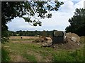
4
Disused Barn, Criplands Court Farm
To the east the land is being developed as a new housing estate, see Image and Image, however, the barn complex still stands facing out onto Image which still survives as an open space. Perhaps the barn will survive as well though for now it sits forlornly waiting its fate.
Image: © Simon Carey
Taken: 4 Aug 2015
0.14 miles
5
Six Acres
The name of the field according to Lindfield's 1845 tithe map that is about to disappear under the second phase of the Heathwood estate development. See also Image to the north.
Image: © Simon Carey
Taken: 4 Aug 2015
0.14 miles
6
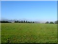
Field Number 834
The number of the field according to Lindfield's 1845 tithe map that wasn't given a name on the survey. Located to the immediate south of the Scaynes Hill Road and East Mascalls Lane road junction. The thick fog of an hour or so earlier still remains in the hollow in the distance.
Image: © Simon Carey
Taken: 9 Aug 2015
0.15 miles
7
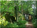
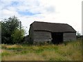
Outbuildings, Seven Acres, Gravelye Lane, Lindfield
A mish mash of styles next to the footpath that links Gravelye Lane to Walstead. They look derelict but do appear to be in use.
Image: © Simon Carey
Taken: 15 Aug 2015
0.16 miles
8
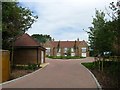
Vetchling House, Lindfield
A block of flats I believe were completed around 2014 on the site of a former field called Two Acres, according to Lindfield's 1845 tithe map. Accessed via Image
Image: © Simon Carey
Taken: 4 Aug 2015
0.16 miles
9
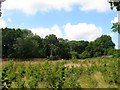
Site of Birchetts Wood (1)
The name of the wood according to Lindfield's 1845 tithe map that once existed here with this part grubbed by the time of the 1875 OS map though others survived until much later, see Image Currently an open access area accessible from a single gate on Lyoth Lane.
Image: © Simon Carey
Taken: 4 Aug 2015
0.17 miles
10
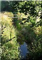
Northlands Brook
A tributary of Scrase Stream that rises in the Northlands estate of Haywards Heath and joins the stream to the north of Walstead Common.
Image: © Simon Carey
Taken: 9 Aug 2015
0.18 miles