IMAGES TAKEN NEAR TO
The Spinney, BURGESS HILL, RH15 8AG
Introduction
This page details the photographs taken nearby to The Spinney, RH15 8AG by members of the Geograph project.
The Geograph project started in 2005 with the aim of publishing, organising and preserving representative images for every square kilometre of Great Britain, Ireland and the Isle of Man.

There are currently over 7.5m images from over14,400 individuals and you can help contribute to the project by visiting https://www.geograph.org.uk
Image Map
Images are licensed for reuse under creativecommons.org/licenses/by-sa/2.0
Notes
- Clicking on the map will re-center to the selected point.
- The higher the marker number, the further away the image location is from the centre of the postcode.
Image Listing (38 Images Found)
Images are licensed for reuse under creativecommons.org/licenses/by-sa/2.0
Image
Details
Distance
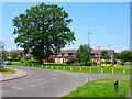
1
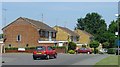
1980s Housing at Leylands Park, Burgess Hill
Burgess Hill has expanded continuously, since the railway first arrived in the nineteenth century. Here we see a typical selection of 1980s built houses built as part of a large estate on the N side of the town.
Image: © Pete Chapman
Taken: 10 Jul 2005
0.03 miles
2
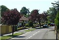
Commuter Land - Noel Rise, Burgess Hill
A residential area of Burgess Hill. The view here is of 1950s houses built close to the main London-Brighton line station at Wivelsfield. There is an area of streets here with a similar style of housing. Burgess Hill is close enough to London to be a dormitory town for London workers.
Image: © Pete Chapman
Taken: 10 Jul 2005
0.10 miles
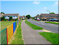
3
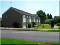
Maple Drive
Housing estate built in the 1980s on the northern edge of the town. The terraces have been built at angles to the road to give each a small garden with garages provided at the rear.
Image: © Simon Carey
Taken: 8 Jun 2008
0.12 miles
5
Maple Drive
Taken from the junction with Leylands Park, this part was built in the 1970s which originally made the estate a cul-de-sac, the extension to London Road was filled in the 1980s.
Image: © Simon Carey
Taken: 8 Jun 2008
0.14 miles
6
Maple Drive
Housing estate built on the northern edge of town in the 1980s.
Image: © Simon Carey
Taken: 8 Jun 2008
0.15 miles
7
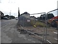
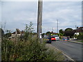
Leylands Road, Burgess Hill
The site on the right is where the gasholders have just been cleared away.
Image: © David Howard
Taken: 9 Aug 2018
0.15 miles
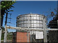
9
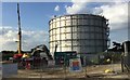
Demolition of the Gas Holder
Demolition work has just started on taking down the old Gas Holder by Leylands Road. This is to make way for a Super Store that is being relocated as part of the planned £65m redevelopment of Burgess Hill Town Centre.
Image: © Chris Thomas-Atkin
Taken: 1 Sep 2017
0.16 miles
10
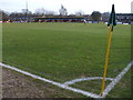
Leylands Park - Burgess Hill Town FC
The Hillians were playing Folkestone. The stadium is on the edge of town up a narrow road to a car park. It is bordered on one side by woodland.
Image: © nick macneill
Taken: 24 Jan 2009
0.17 miles