IMAGES TAKEN NEAR TO
Northway, BURGESS HILL, RH15 0PP
Introduction
This page details the photographs taken nearby to Northway, RH15 0PP by members of the Geograph project.
The Geograph project started in 2005 with the aim of publishing, organising and preserving representative images for every square kilometre of Great Britain, Ireland and the Isle of Man.

There are currently over 7.5m images from over14,400 individuals and you can help contribute to the project by visiting https://www.geograph.org.uk
Image Map
Images are licensed for reuse under creativecommons.org/licenses/by-sa/2.0
Notes
- Clicking on the map will re-center to the selected point.
- The higher the marker number, the further away the image location is from the centre of the postcode.
Image Listing (24 Images Found)
Images are licensed for reuse under creativecommons.org/licenses/by-sa/2.0
Image
Details
Distance
3
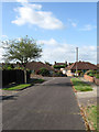
Manor Close, World's End
Small cul-de-sac off Manor Road in an area of Burgess Hill built up after the Second World War.
Image: © Simon Carey
Taken: 28 Aug 2009
0.13 miles
4
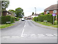
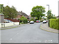
Eastdale Road, World's End
Small suburban road linking Manor Road with Northway. Much of the housing here was built after the Second World War.
Image: © Simon Carey
Taken: 28 Aug 2009
0.16 miles
6
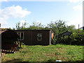
Awaiting Development, World's End
Small plot off Manor Road that has planning position for the construction of five houses. Looks like a former smallholding of some sort.
Image: © Simon Carey
Taken: 28 Aug 2009
0.18 miles
7
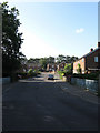
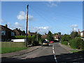
Manor Road, World's End
A suburb of Burgess Hill with this part being very much a post war creation. The railings in the foreground mark out a bridge as the road crosses a small stream, a tributary of the eastern branch of the River Adur.
Image: © Simon Carey
Taken: 28 Aug 2009
0.19 miles
8
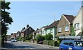
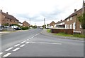
Junction Road, Burgess Hill
A view looking SW along Junction Road. Typical suburban housing, built around the start of the 20th century, and in a convenient catchment area to Wivelsfield Station (approximately a quarter of a mile away) - classic commuter housing.
Image: © Pete Chapman
Taken: 10 Jul 2005
0.20 miles
9
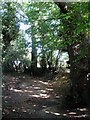
Old Field Boundary
The small embankment which lies next to an old right of way is still extant. The field still lies beyond it but a couple of steps to the left and you emerge from the foliage into suburban Burgess Hill.
Image: © Simon Carey
Taken: 28 Aug 2009
0.22 miles
10
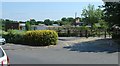
Manor Field County Primary School, Worlds End, Burgess Hill, West Sussex
A primary school off Junction Road, Burgess Hill. View taken from Junction Road, looking NE.
Image: © Pete Chapman
Taken: 10 Jul 2005
0.22 miles