IMAGES TAKEN NEAR TO
Alexandra Road, BURGESS HILL, RH15 0EW
Introduction
This page details the photographs taken nearby to Alexandra Road, RH15 0EW by members of the Geograph project.
The Geograph project started in 2005 with the aim of publishing, organising and preserving representative images for every square kilometre of Great Britain, Ireland and the Isle of Man.

There are currently over 7.5m images from over14,400 individuals and you can help contribute to the project by visiting https://www.geograph.org.uk
Image Map
Images are licensed for reuse under creativecommons.org/licenses/by-sa/2.0
Notes
- Clicking on the map will re-center to the selected point.
- The higher the marker number, the further away the image location is from the centre of the postcode.
Image Listing (13 Images Found)
Images are licensed for reuse under creativecommons.org/licenses/by-sa/2.0
Image
Details
Distance
1
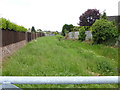
Drainage channel between Marlborough Drive and Alexandra Road
Image: © Shazz
Taken: 24 May 2016
0.06 miles
3
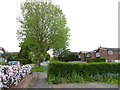
Looking over the hedge from Churchill Way to Oakwood Road
Image: © Shazz
Taken: 24 May 2016
0.08 miles
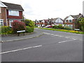
4
Silverdale Road
Looking eastwards towards the junction with Alexandra Road.
Image: © Curtis Bateman
Taken: 29 Jul 2010
0.15 miles
5
One O'clock Crossing
A local story goes that there was once a very devoted labourer on a local farm, who on his master's death was bequeathed a pocket watch. Although unable to tell the time, he cherished the watch and if asked the time he would study the watch and then announce "One O'clock Sir", no matter whether it was morning, noon, or night. Consequently the labourer was known to live at One O'clock Farm.
Image: © Peter Jeffery
Taken: 1 Mar 2008
0.20 miles
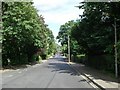
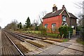
6
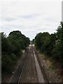
Towards Keymer Junction
The rail link between the London-Brighton line at Keymer Junction and Lewes was opened in 1847. This view from Kings Way road bridge also takes in another older crossing just ahead which still has its original crossing keeper's house amongst the modern day suburbia of Burgess Hill.
Image: © Simon Carey
Taken: 16 Aug 2009
0.21 miles
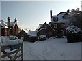
8
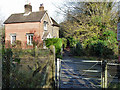
Bridleway level crossing and cottage
Although this was the only public crossing in the neighbourhood in former times, it seems unlikely it merited a crossing keeper, although the cottage appears to be, or have been, on railway land.
Image: © Robin Webster
Taken: 19 Nov 2010
0.23 miles
9
Burgess Hill School For Girls
This building belongs to Burgess Hill School For Girls. The photo was taken on Silverdale Road.
Image: © Curtis Bateman
Taken: 7 Jan 2010
0.23 miles
10
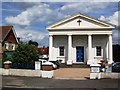
All Saints United Reformed Church, Junction Road
Taken from the opposite side of Junction Road, the road runs south to Hoadley's Corner and north towards World's End.
Image: © Curtis Bateman
Taken: 29 Jul 2010
0.24 miles