IMAGES TAKEN NEAR TO
The Old Sussex Stud, Cowfold Road, HORSHAM, RH13 8JP
Introduction
This page details the photographs taken nearby to The Old Sussex Stud, Cowfold Road, RH13 8JP by members of the Geograph project.
The Geograph project started in 2005 with the aim of publishing, organising and preserving representative images for every square kilometre of Great Britain, Ireland and the Isle of Man.

There are currently over 7.5m images from over14,400 individuals and you can help contribute to the project by visiting https://www.geograph.org.uk
Image Map
Images are licensed for reuse under creativecommons.org/licenses/by-sa/2.0
Notes
- Clicking on the map will re-center to the selected point.
- The higher the marker number, the further away the image location is from the centre of the postcode.
Image Listing (28 Images Found)
Images are licensed for reuse under creativecommons.org/licenses/by-sa/2.0
Image
Details
Distance
1
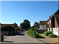
The Old Sussex Stud
Park Farm was built between 1793 and 1815 in order to remove the farm business away from the environs of West Grinstead Park. The latter was acquired by JP Hornung, a businessman who acquired his riches through cultivating sugar cane in Portuguese East Africa and brother to Raffles creator EW Hornung. Hornung's hobby was horseracing and he established a stud at Park Farm in 1921. After his death in 1940 it was acquired by the National Stud in 1949 and continued in operation until it went into liquidation in 1985. The entire stud was converted to housing around the turn of this century. The white building on the left known as the White House was once the Grooms House whilst beyond is the Old Dairy which were originally offices for the stud.
Image: © Simon Carey
Taken: 19 Jul 2016
0.03 miles
2
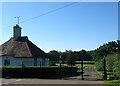
The Bungalow, Old Sussex Stud
Dating from the 1920s when Park Farm was converted into a stud farm by JP Hornung owner of West Grinstead Park. Beyond is Image
Image: © Simon Carey
Taken: 19 Jul 2016
0.04 miles
3
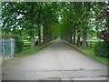
Park Farm
Approach to Park Farm. A private road for residents & visitors and also Footpath 1793
Image: © The Saunterer
Taken: 17 May 2012
0.06 miles
4
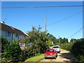
Kippens Lane
A private cul de sac off the A24 viewed from the eastern end beyond a locked gate. The two pairs of semi-detached cottages on the left were built in the 1960s to replace a single pair of 19th century cottages. Beyond the hedge to the north is Image
Image: © Simon Carey
Taken: 19 Jul 2016
0.08 miles
5
Footpath 1793 through the grounds of The Old Sussex Stud
Image: © Dave Spicer
Taken: 27 Sep 2011
0.09 miles
6
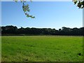
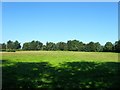
Kippings Field (2)
The name of the field according to West Grinstead's 1841 tithe map. This is the smaller eastern portion of the field bounded by the A272 to the north and the former buildings of Park Farm to the south. It is separated from Image to the west by Image
Image: © Simon Carey
Taken: 19 Jul 2016
0.09 miles
7
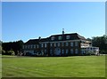
The Main House, Old Sussex Stud
Despite the looks the house was built in either the 1960s or 70s. It occupies the north west corner of what was Cow Hovel Field, according to West Grinstead's 1841 tithe map.
Image: © Simon Carey
Taken: 19 Jul 2016
0.10 miles
8
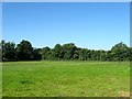
House Mead
The name of the field according to West Grinstead's 1841 tithe map which lies to the west of Image
Image: © Simon Carey
Taken: 19 Jul 2016
0.11 miles
9
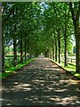
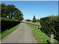
Drive to Park Farm
Looking northwards from the edge of park Farm towards the A272. Beyond is another treelined drive to Model Farm Cottages, see Image Either side of this drive is Image to the left and Image to the right.
Image: © Simon Carey
Taken: 19 Jul 2016
0.11 miles
10
Kippings Field (1)
The name of the field according to West Grinstead's 1841 tithe map. The field has now been split into two separate sections by the construction of Image sometime between the wars. This is the western part bounded by the A272 to the north, the A24 to the west and Image to the south. See Image for the eastern part.
Image: © Simon Carey
Taken: 19 Jul 2016
0.14 miles