IMAGES TAKEN NEAR TO
Brighton Road, HORSHAM, RH13 8HD
Introduction
This page details the photographs taken nearby to Brighton Road, RH13 8HD by members of the Geograph project.
The Geograph project started in 2005 with the aim of publishing, organising and preserving representative images for every square kilometre of Great Britain, Ireland and the Isle of Man.

There are currently over 7.5m images from over14,400 individuals and you can help contribute to the project by visiting https://www.geograph.org.uk
Image Map
Images are licensed for reuse under creativecommons.org/licenses/by-sa/2.0
Notes
- Clicking on the map will re-center to the selected point.
- The higher the marker number, the further away the image location is from the centre of the postcode.
Image Listing (11 Images Found)
Images are licensed for reuse under creativecommons.org/licenses/by-sa/2.0
Image
Details
Distance
1
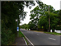
Bus Stops, Shermanbury
Served by the number 17 that travels between Brighton and Horsham. Shermanbury's development has straggled ribbon like down the eastern side of the A281.
Image: © Simon Carey
Taken: 26 Aug 2006
0.12 miles
2
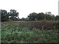
Ricksteddle Mead
The name of the field according to the 1840 tithe map viewed from Wychwood Lane.
Image: © Simon Carey
Taken: 2 Oct 2010
0.17 miles
3
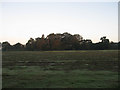
Lady Land
The name of the field according to the 1840 tithe map. The name derives the Virgin Mary and is either land wholly dedicated to her or land where the rent was due to fall on Lady Day, the feast of the annunciation, which fell on 25 March, and was the original New Years Day and the traditional time for farmers to take possession of new farms and fields. Taken a few minutes after sunrise with the trees on the far side just beginning to reflect the orange glow of the early morning sun.
Image: © Simon Carey
Taken: 18 Sep 2010
0.19 miles
5
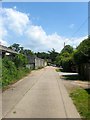
Wychwood Lane, Shermanbury
A private lane providing access to a number of properties including Image after which it becomes a footpath that continues westwards to the Downs Link. Much of the development occurred after the Second World War.
Image: © Simon Carey
Taken: 18 Jun 2017
0.19 miles
6
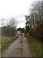
Wychwood Lane
Private road that serves the residences of both Wychwood Farm and a couple of other houses off the A281. The road is also a public footpath.
Image: © Simon Carey
Taken: 29 Nov 2009
0.20 miles
7
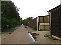
Wychwood Lane
A private drive off Brighton Road, the A281. It is also the public footpath that links Shermanbury to the Downs Link.
Image: © Simon Carey
Taken: 2 Oct 2010
0.21 miles
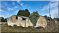
8
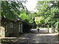
Lodge Cottage
The former western lodge for Shermanbury Place. Beyond the gate is the A281.
Image: © Simon Carey
Taken: 18 Sep 2010
0.24 miles
9
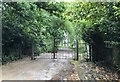
Track to Shermanbury Place
The gates at the entrance to Shermanbury Place just off the A281.
Image: © Chris Thomas-Atkin
Taken: 8 Jun 2020
0.24 miles
10

Avenue of trees
The trees line the track leading to Shermanbury Place.
Image: © Chris Thomas-Atkin
Taken: 8 Jun 2020
0.25 miles