IMAGES TAKEN NEAR TO
Partridge Green Road, HORSHAM, RH13 8HA
Introduction
This page details the photographs taken nearby to Partridge Green Road, RH13 8HA by members of the Geograph project.
The Geograph project started in 2005 with the aim of publishing, organising and preserving representative images for every square kilometre of Great Britain, Ireland and the Isle of Man.

There are currently over 7.5m images from over14,400 individuals and you can help contribute to the project by visiting https://www.geograph.org.uk
Image Map
Images are licensed for reuse under creativecommons.org/licenses/by-sa/2.0
Notes
- Clicking on the map will re-center to the selected point.
- The higher the marker number, the further away the image location is from the centre of the postcode.
Image Listing (15 Images Found)
Images are licensed for reuse under creativecommons.org/licenses/by-sa/2.0
Image
Details
Distance
1
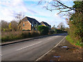
Wagstaff Cottages, Partridge Green Road, Shermanbury
Modern cottages on the B2116 road to Partridge Green.
Image: © Simon Carey
Taken: 22 Nov 2008
0.01 miles
2
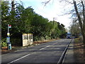
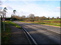
The east end of Partridge Green Road with bus stops
Image: © Shazz
Taken: 11 Jan 2017
0.10 miles
3
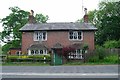
Old Toll House by the A281, Brighton Road, Shermanbury
Corner House by the A281, in parish of Shermanbury (Horsham District), Toll Cottage (Corner House), Brighton Road, RH13 8HB.
Grade II listed.
List Entry Number: 1354042 https://historicengland.org.uk/listing/the-list/list-entry/1354042
Surveyed
Milestone Society National ID: WS.SHE
Image: © Milestone Society
Taken: Unknown
0.12 miles
4

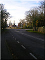
Junction of Partridge Green and Brighton Roads
There is a signed footpath off to the right.
Image: © Shazz
Taken: 11 Jan 2017
0.12 miles
5
Cornerhouse
The area of Shermanbury named after a former farm that was located on the corner of the Henfield-Horsham and Partridge Green roads. The former is the modern day A281, the latter the B2116.
Image: © Simon Carey
Taken: 22 Nov 2008
0.12 miles

7
Bend in the Road
Most likely to have been caused by the meeting of parish boundaries at the tip of the bend. Here Partridge Green Road, Shermanbury becomes Shermanbury Road, Partridge Green at the entrance to Shermanbury Grange, though the latter is officially in West Grinstead parish. The road was already in existence during the 17th century and is the modern day B2116.
Image: © Simon Carey
Taken: 22 Nov 2008
0.15 miles
8
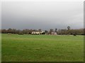
Shermanbury Grange
Built in 1843 on the site of an older farm and former manor house. The smaller building to the right is The Gate House.
Image: © Simon Carey
Taken: 29 Nov 2009
0.16 miles
9
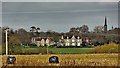
Shermanbury Grange
This is a cross-grid telephoto shot. The camera was on the Downs Link footpath in TQ1917 - about 1.5 km away. The spire of St Hugh's Charterhouse monastery can also be seen on the right. The monastery is about 3 km from the camera.
Image: © Ian Hawfinch
Taken: 15 Mar 2020
0.17 miles
10
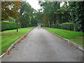
Drive side lawns to private property at Shermanbury
Image: © Dave Spicer
Taken: 19 Sep 2009
0.18 miles