IMAGES TAKEN NEAR TO
Elmwood Road, REDHILL, RH1 2JD
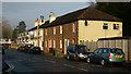
Introduction
This page details the photographs taken nearby to Elmwood Road, RH1 2JD by members of the Geograph project.
The Geograph project started in 2005 with the aim of publishing, organising and preserving representative images for every square kilometre of Great Britain, Ireland and the Isle of Man.

There are currently over 7.5m images from over14,400 individuals and you can help contribute to the project by visiting https://www.geograph.org.uk
Image Map
Images are licensed for reuse under creativecommons.org/licenses/by-sa/2.0
Notes
- Clicking on the map will re-center to the selected point.
- The higher the marker number, the further away the image location is from the centre of the postcode.
Image Listing (58 Images Found)
Images are licensed for reuse under creativecommons.org/licenses/by-sa/2.0
Image
Details
Distance
1
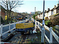
'Road up' in Elmwood Road
According to the notice, for relaying the gas main.
Image: © Robin Webster
Taken: 16 Nov 2010
0.04 miles
2
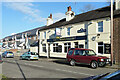
Jolly Brickmakers, Holmethorpe
A pub on Frenches Road.
Image: © Robin Webster
Taken: 16 Nov 2010
0.08 miles
3
The 'Jolly Brickmakers', Redhill, Surrey
Located on Frenches Road, in the former hamlet of Holmethorpe.
Image: © Peter Trimming
Taken: 10 Dec 2013
0.08 miles
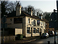
4
The Jolly Brickmakers
Unusually forming one end of a terrace of houses, dating from Victorian times.
Image: © Ian Capper
Taken: 9 May 2009
0.08 miles
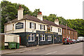
5
Frenches Road, Holmethorpe, Redhill, Surrey
Late Victorian terrace nearest the camera, with modern housing in the distance. In between, lies the 'Jolly Brickmakers' public house.
Image: © Peter Trimming
Taken: 10 Dec 2013
0.09 miles
6
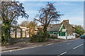
Frenches Road
Buildings in Frenches Road. On the left is the Frenches Lodge, a former Surrey County Council day centre, catering for adults with physical disabilities, closed in 2015 due to relocation (see Image) and beyond is Masjid ul-Emaan, an Islamic community education centre (see Image).
Image: © Ian Capper
Taken: 31 Oct 2019
0.09 miles
7
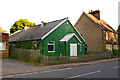
Battlebridge Hall
This hall in Frenches Road has the appearance of a "tin tabernacle", the nickname given to corrugated iron structures, often used for mission churches, around the turn of the 19th/20th centuries. I have not been able to identify its history, other than a reference to its use by All Saints Church Merstham near the beginning of the second world war, and more recent references to "Battlebridge Education Centre" at what would appear to be this address. The name "Battlebridge Hall" is what appears on very large scale maps.
Image: © Ian Capper
Taken: 15 Jun 2008
0.09 miles
8
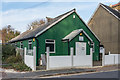
Masjid ul-Emaan
The former Battlebridge Hall, a "tin tabernacle" dating from the early 20th Century, now used as an Islamic community education centre. See Image for a photo from 2008.
Image: © Ian Capper
Taken: 31 Oct 2019
0.09 miles
9
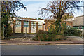
Frenches Lodge
Former Surrey County Council day centre, catering for adults with physical disabilities, closed in 2015 due to relocation.
Image: © Ian Capper
Taken: 31 Oct 2019
0.09 miles
10
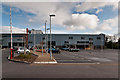
East Surrey College
Part of East Surrey College. What was at the time Redhill Technical College moved to this site in 1970, becoming East Surrey College in 1983 following merger with the Reigate and Redhill School of Arts and Crafts. A major redevelopment of the site was completed in 2010, with some of the new building being seen here.
Image: © Ian Capper
Taken: 21 Apr 2012
0.11 miles