IMAGES TAKEN NEAR TO
Frenches Road, REDHILL, RH1 2HZ
Introduction
This page details the photographs taken nearby to Frenches Road, RH1 2HZ by members of the Geograph project.
The Geograph project started in 2005 with the aim of publishing, organising and preserving representative images for every square kilometre of Great Britain, Ireland and the Isle of Man.

There are currently over 7.5m images from over14,400 individuals and you can help contribute to the project by visiting https://www.geograph.org.uk
Image Map
Images are licensed for reuse under creativecommons.org/licenses/by-sa/2.0
Notes
- Clicking on the map will re-center to the selected point.
- The higher the marker number, the further away the image location is from the centre of the postcode.
Image Listing (39 Images Found)
Images are licensed for reuse under creativecommons.org/licenses/by-sa/2.0
Image
Details
Distance
1
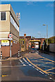
Trowers Way
Prior to the 2005 completion of a new bridge on Ormside Way (see Image), this narrow and low bridge under the London-Brighton railway, turning straight from the residential Frenches Road (visible through the bridge) was the main road access into the Holmethorpe Industrial Estate - hardly suitable.
Image: © Ian Capper
Taken: 21 Apr 2012
0.03 miles
2
Holmethorpe Avenue
A unit on Holmethorpe Avenue, in the Holmethorpe Industrial Estate. The level crossing gate on the left is the only remaining evidence of the sidings that connected the British Industrial Sand works, now the site of the Watercolour development, with the London-Brighton railway, a link which operated until the mid 1980s.
Image: © Ian Capper
Taken: 21 Apr 2012
0.04 miles
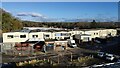
3
Trowers Way
Units on Trowers Way, in the Holmethorpe Industrial Estate.
Image: © Ian Capper
Taken: 21 Apr 2012
0.06 miles
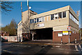
4
Frenches Lodge
Former Surrey County Council day centre, catering for adults with physical disabilities, closed in 2015 due to relocation.
Image: © Ian Capper
Taken: 31 Oct 2019
0.08 miles
5
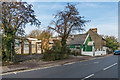
Frenches Road
Buildings in Frenches Road. On the left is the Frenches Lodge, a former Surrey County Council day centre, catering for adults with physical disabilities, closed in 2015 due to relocation (see Image) and beyond is Masjid ul-Emaan, an Islamic community education centre (see Image).
Image: © Ian Capper
Taken: 31 Oct 2019
0.09 miles
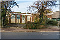
6
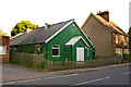
Battlebridge Hall
This hall in Frenches Road has the appearance of a "tin tabernacle", the nickname given to corrugated iron structures, often used for mission churches, around the turn of the 19th/20th centuries. I have not been able to identify its history, other than a reference to its use by All Saints Church Merstham near the beginning of the second world war, and more recent references to "Battlebridge Education Centre" at what would appear to be this address. The name "Battlebridge Hall" is what appears on very large scale maps.
Image: © Ian Capper
Taken: 15 Jun 2008
0.09 miles
7
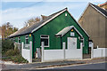
Masjid ul-Emaan
The former Battlebridge Hall, a "tin tabernacle" dating from the early 20th Century, now used as an Islamic community education centre. See Image for a photo from 2008.
Image: © Ian Capper
Taken: 31 Oct 2019
0.09 miles
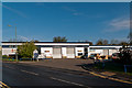
8
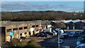
Ormside Way Industrial units
Front elevations of some of the units in Ormside Way
Image: © Marvin653
Taken: 2 Dec 2021
0.11 miles
9
Ormside Way Industrial Estate
Elevations of some of the units in the Ormside Way Industrial Estate, Redhill
Image: © Marvin653
Taken: 2 Dec 2021
0.11 miles
10
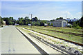
Railway yard, Holmethorpe, Redhill, 1990
British Industrial Sand had pits and processing plant through the arch under the main Brighton "Quarry Line" in the distance, and sand trains were handled in this yard by their locomotives. Two of these are on view, one with bushes growing around it, the other more recently used. Little or no sand traffic was handled in 1990, all of this has gone now.
Image: © Robin Webster
Taken: Unknown
0.13 miles