IMAGES TAKEN NEAR TO
Bucklebury Road, READING, RG7 6EF
Introduction
This page details the photographs taken nearby to Bucklebury Road, RG7 6EF by members of the Geograph project.
The Geograph project started in 2005 with the aim of publishing, organising and preserving representative images for every square kilometre of Great Britain, Ireland and the Isle of Man.

There are currently over 7.5m images from over14,400 individuals and you can help contribute to the project by visiting https://www.geograph.org.uk
Image Map
Images are licensed for reuse under creativecommons.org/licenses/by-sa/2.0
Notes
- Clicking on the map will re-center to the selected point.
- The higher the marker number, the further away the image location is from the centre of the postcode.
Image Listing (105 Images Found)
Images are licensed for reuse under creativecommons.org/licenses/by-sa/2.0
Image
Details
Distance
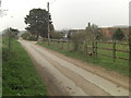
1
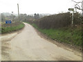
T-junction at the end of Back Lane
The road on the left has come west from Stanford Dingley. Users can turn left towards Bucklebury Village, where St Mary's Church spire can be seen in the distance; or right towards the photographer.
Image: © Stuart Logan
Taken: 29 Mar 2011
0.02 miles
2
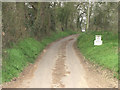
A country cul-de-sac
A short but pretty lane winds northwards to the superb Old Hawkridge House and then becomes BUCK/18/6. This wooded path offers several options as it crosses a network of paths which traverse the high woodland.
Image: © Stuart Logan
Taken: 29 Mar 2011
0.03 miles
3
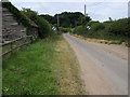
Lane heading towards New Barn Farm
Lane heading away from Bucklebury towards New Barn Farm
Image: © Shaun Ferguson
Taken: 27 Jun 2008
0.05 miles
4
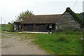
Stables at Bucklebury
Just north of the bridge over the River Pang.
Image: © Graham Horn
Taken: 25 Sep 2008
0.08 miles
5
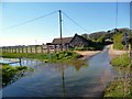
The Relief Channel is Working
Following flooding from the River Pang in Bucklebury village, a relief channel has been made by-passing affected properties. 2012/13 has seen high flows again, and the new channel is doing its job.
The resulting temporary watersplash is a minor inconvenience by comparison.
Image: © Des Blenkinsopp
Taken: 2 May 2013
0.11 miles
6

Streambed of the River Pang at Bucklebury
The streambed seems all but dry, the flow little more than a trickle. The reason, no doubt, is that a relief channel was dug after flooding earlier in the century: http://www.geograph.org.uk/photo/3469627 http://www.geograph.org.uk/photo/503402
Image: © Stefan Czapski
Taken: 7 Sep 2018
0.13 miles
7
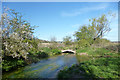
River Pang Above The Mill
Just beyond this derelict bridge is the ruined mill shown in Image
Image: © Des Blenkinsopp
Taken: 2 May 2013
0.13 miles
8
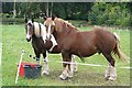
Stable companions
Two horses stop their feeding and pose for the camera in a paddock north of the church.
Image: © Graham Horn
Taken: 25 Sep 2008
0.14 miles
9
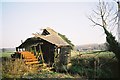
Remains of a Mill in 1993
I thought I had lost this one. This is the same mill as in my 2013 picture Image only taken 20 years earlier.
Enough of the structure still remains to get an idea of what the working mill must have been like.
Image: © Des Blenkinsopp
Taken: 20 Apr 1993
0.14 miles
10
Entrance to BUCK/103/1 next to New Barn Farm
This footpath climbs towards the wooded environs of Frilsham.
Image: © Stuart Logan
Taken: 29 Mar 2011
0.14 miles