IMAGES TAKEN NEAR TO
Bucklebury Road, READING, RG7 6EA
Introduction
This page details the photographs taken nearby to Bucklebury Road, RG7 6EA by members of the Geograph project.
The Geograph project started in 2005 with the aim of publishing, organising and preserving representative images for every square kilometre of Great Britain, Ireland and the Isle of Man.

There are currently over 7.5m images from over14,400 individuals and you can help contribute to the project by visiting https://www.geograph.org.uk
Image Map
Images are licensed for reuse under creativecommons.org/licenses/by-sa/2.0
Notes
- Clicking on the map will re-center to the selected point.
- The higher the marker number, the further away the image location is from the centre of the postcode.
Image Listing (31 Images Found)
Images are licensed for reuse under creativecommons.org/licenses/by-sa/2.0
Image
Details
Distance
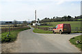
1
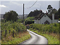
Road and cottage, Stanford Dingley
The road to Bucklebury viewed from the entrance to Pangfield Farm.
Image: © Andrew Smith
Taken: 4 Sep 2009
0.02 miles
2
Pangfield Cottages
Near to Pangfield Farm.
Image: © Oscar Taylor
Taken: 23 Aug 2023
0.02 miles
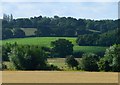
3
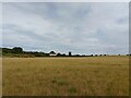
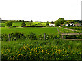
Pangfield field
In the distance are Pangfield Cottages.
Image: © Oscar Taylor
Taken: 23 Aug 2023
0.02 miles
4
Pangfield Farm near Bucklebury
This farm is situated in the upper half of the grid square, more or less in the middle. The picture was taken south of the farm from the road looking more or less north west. (Pig Farm).
Image: © Pam Brophy
Taken: 6 May 2005
0.03 miles
5
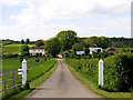
Pangfield Farm near Bucklebury
The farm in the spring sunshine. This view was taken from the west of the drive up to the farm looking in a north westerly direction. The farm is in the middle of the upper half of the grid square.
Image: © Pam Brophy
Taken: 6 May 2005
0.03 miles
6
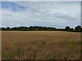
In the Pang valley
From a footpath adjacent to the River Pang, looking north-west across recently harvested arable land towards a house on the Bucklebury to Stanford Dingley Road.
Image: © Graham Horn
Taken: 25 Sep 2008
0.06 miles
7
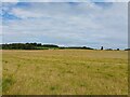
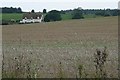
Sunridge and farmland
The house in the distance is Sunridge.
Image: © Oscar Taylor
Taken: 23 Aug 2023
0.11 miles
8
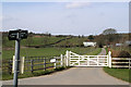
Public right of way ST AN 2/2 at junction with Back Lane
ST AN 2/2 is a restricted byway which also forms the driveway to Pangfield Farm. The farm can be seen in the picture.
Image: © Stuart Logan
Taken: 12 Mar 2011
0.11 miles
9
Byway junction with Back Lane
Back Lane goes west to Bucklebury, which will get its post soon! ST AN 1/1 joins the crossroads from the left and ST AN 2/2 heads away to the North.
Image: © Stuart Logan
Taken: 12 Mar 2011
0.12 miles
10
Pastoral scene, Stanford Dingley, Berkshire
Image: © Oswald Bertram
Taken: 4 Aug 2015
0.13 miles