IMAGES TAKEN NEAR TO
Front Street, HUNGERFORD, RG17 7HJ
Introduction
This page details the photographs taken nearby to Front Street, RG17 7HJ by members of the Geograph project.
The Geograph project started in 2005 with the aim of publishing, organising and preserving representative images for every square kilometre of Great Britain, Ireland and the Isle of Man.

There are currently over 7.5m images from over14,400 individuals and you can help contribute to the project by visiting https://www.geograph.org.uk
Image Map
Images are licensed for reuse under creativecommons.org/licenses/by-sa/2.0
Notes
- Clicking on the map will re-center to the selected point.
- The higher the marker number, the further away the image location is from the centre of the postcode.
Image Listing (45 Images Found)
Images are licensed for reuse under creativecommons.org/licenses/by-sa/2.0
Image
Details
Distance
1
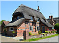
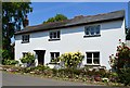
Bay Tree Cottage, East Garston, Berkshire
C17 with C20 alterations. Brick and timber framing with brick infill. Thatched roof ½ hipped, chimney to right. 1½ storeys. Three C20 square dormers cut into thatch at eaves. Two C20 casements to left and C20 lean to porch to right.
(Source:Historic England)
Image: © Oswald Bertram
Taken: 4 Jun 2015
0.01 miles
2
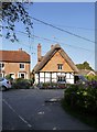
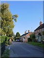
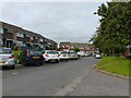
East Garston: cottages in Station Road
There are dwellings of three quite disparate dates in the picture.
Timber-framed cottages with thatched roofs are typical of the villages along the Lambourn valley, and the one in the picture probably dates from before 1700. Tile-hanging - it has to be said - is less often seen in West Berkshire than in Kent or Surrey.
The brick-built cottage to the left may well date from the period between 1880 and the outbreak of the Great War. Further back (perhaps sited in a cul-de-sac) are bungalows of much more recent date.
Image: © Stefan Czapski
Taken: 10 Oct 2018
0.01 miles
3
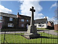
War Memorial, East Garston: late March 2016
Image: © Basher Eyre
Taken: 29 Mar 2016
0.03 miles
4
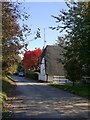
East Garston in October
The cottage with the thatched cat-slide roof is known as Lamb's Cottage. The stream-bed of the Lambourn - just behind it - seemed completely dry, despite a good deal of rain in recent weeks.
Image: © Stefan Czapski
Taken: 10 Oct 2018
0.04 miles
5
Village house, East Garston, Berkshire
Image: © Oswald Bertram
Taken: 4 Jun 2015
0.04 miles
6
East Garston: Back Street
Or is this stretch known as Rogers's Lane? In any case, behind the camera the lane leads uphill to join the main Great Shefford-Lambourn road.
Photo taken on a warm day in early October.
Image: © Stefan Czapski
Taken: 10 Oct 2018
0.05 miles
7
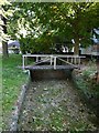
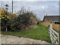
East Garston: stream-bed of the Lambourn, October 2018
'Bourn' is often met with in the names of streams in chalky counties such as Berkshire, Hampshire, Wiltshire and Dorset - and is generally understood to indicate a stream which flows seasonally, drying up in summer. In this instance, the Lambourn seemed pretty much bone-dry in October - even though the summer's drought had been followed by a good deal of wet weather.
At East Garston the stream-bed is crossed by at least five of these little pedestrian bridges, giving access to cottages.
It occurs to me that a number of 'bourn' villages I've visited while Geographing have features in common - in that the stream has been canalised into a narrow bed, and the older dwellings are strung out along it, built directly on its banks. Economic use must have been made of the stream, even though it flowed for just a few months of the year.
Winterbourne, West Berkshire, comes to mind Image Image and so does Image, in Wiltshire.
Image: © Stefan Czapski
Taken: 10 Oct 2018
0.06 miles
8
Site of former East Garston station, 1992
View westward, towards Lambourn: ex-GWR Newbury - Lambourn branch, closed 4/1/60.
Image: © Ben Brooksbank
Taken: 25 Oct 1992
0.08 miles
10
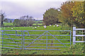
East Garston railway station (site), Berkshire
Opened in 1898 by the Lambourn Valley Railway, later part of the Great Western Railway, on its branch from Newbury to Lambourn, this station closed to passengers in 1960.
View east towards Great Shefford and Newbury. The view is along the former single railway track, with the one platform having been to the right of it, where the bungalow now is. No trace of the station apparently remains.
For more information, see http://www.disused-stations.org.uk/e/east_garston/index.shtml.
Image: © Nigel Thompson
Taken: 10 Nov 2022
0.08 miles