IMAGES TAKEN NEAR TO
RG16 7TH
Introduction
This page details the photographs taken nearby to RG16 7TH by members of the Geograph project.
The Geograph project started in 2005 with the aim of publishing, organising and preserving representative images for every square kilometre of Great Britain, Ireland and the Isle of Man.

There are currently over 7.5m images from over14,400 individuals and you can help contribute to the project by visiting https://www.geograph.org.uk
Image Map
Images are licensed for reuse under creativecommons.org/licenses/by-sa/2.0
Notes
- Clicking on the map will re-center to the selected point.
- The higher the marker number, the further away the image location is from the centre of the postcode.
Image Listing (15 Images Found)
Images are licensed for reuse under creativecommons.org/licenses/by-sa/2.0
Image
Details
Distance
1
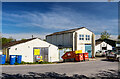
WWII Berkshire: RAF Membury - Main Stores
A good example of an RAF station's wartime Main Stores that are in a good state of preservation today thanks to their continued use in a different role on a modern industrial estate.
Image
RAF MEMBURY - OVERVIEW
KEY FACTS:
Airfield opened in August 1942, and planned as a Bomber OTU but transferred instead to the USAAF and designated USAAF Station 466.
September 1942 Membury designated for use by 8th Air Force Ground Air Support Command for its reconnaissance units (3rd Photographic and 67th Observation Groups).
October 1942 the 3rd Photographic moved to RAF Steeple Morden prior to embarkation to North Africa.
Winter of 1942/43 occupation by 6th Tactical Air Depot specialising in the repair and modification of Republic P-47 Thunderbolts.
January 1944 arrival of 366th Fighter Group from North Carolina.
3 March 1944 arrival of 436th Troop Carrier Group with Douglas C47 and C53 Skytrains, assigned to the 53rd Troop Carrier Wing.
February 1945 53rd Troop Carrier Wing moved its groups to France.
June 1945 RAF Membury returned to the RAF.
October 1945 under 'Care & Maintenance' and eventual closure.
Image: © Mike Searle
Taken: 26 Apr 2021
0.02 miles
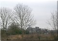
4
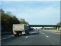
M4 exit for Membury Services
Membury Services is located on the old site of RAF Membury, a major supply and maintenance depot, and is next to the Membury Radio Mast, a 500 feet high mast erected in 1965.
Image: © Julian P Guffogg
Taken: 7 Aug 2013
0.11 miles
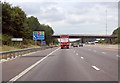
6
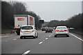
West Berkshire : M4 Motorway
The M4 Motorway between Junction 15 (Plough Hill Interchange) and Junction 14 (Hungerford Interchange).
Image: © Lewis Clarke
Taken: 23 Mar 2018
0.11 miles
7
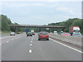
M4 roadbridge - adjoining Membury Services
Image: © Stuart Logan
Taken: 13 Jul 2011
0.12 miles
8
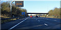
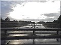
Westbound M4
Ramsbury Road crosses the bridge, Membury services are just beyond.
Image: © Robin Webster
Taken: 19 Jan 2020
0.12 miles
9
The M4 by Membury Services
It was pouring with rain as it did for around an hour around the area
Image: © David Howard
Taken: 30 Jul 2017
0.13 miles
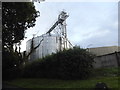
10
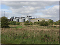
Ridgeway Grains Limited
Part of the Membury Airfield industrial estate.
Image: © Andrew Smith
Taken: 8 Oct 2006
0.14 miles