IMAGES TAKEN NEAR TO
RG16 0SE
Introduction
This page details the photographs taken nearby to RG16 0SE by members of the Geograph project.
The Geograph project started in 2005 with the aim of publishing, organising and preserving representative images for every square kilometre of Great Britain, Ireland and the Isle of Man.

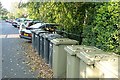
There are currently over 7.5m images from over14,400 individuals and you can help contribute to the project by visiting https://www.geograph.org.uk
Image Map
Images are licensed for reuse under creativecommons.org/licenses/by-sa/2.0
Notes
- Clicking on the map will re-center to the selected point.
- The higher the marker number, the further away the image location is from the centre of the postcode.
Image Listing (176 Images Found)
Images are licensed for reuse under creativecommons.org/licenses/by-sa/2.0
Image
Details
Distance
1
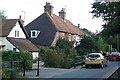
Houses in Hampstead Norreys
One of the main residential streets in this attractive village.
Image: © Graham Horn
Taken: 28 Sep 2008
0.02 miles
2
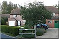
Houses on the railway line
These two houses are on the route of the former Didcot, Newbury, Southampton railway line that ran through Hampstead Norreys. There is little evidence that the line went through here. Well just one clue - the house on the right is called "Beechings". The doctor will turn in his grave.
Image: © Graham Horn
Taken: 28 Sep 2008
0.02 miles
3
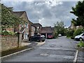
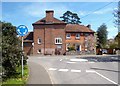
Hampstead Norris railway station (site), Berkshire
Opened in 1882 by the Didcot Newbury & Southampton Railway, later part of the Great Western Railway, this station closed to passengers in 1962 and completely in 1964.
Former forecourt looking south. The buildings on the left stand on the site of the station, the platforms being on an embankment which has now mostly been removed. The village is now called 'Hampstead Norreys' but the station name was never spelled this way.
Image: © Nigel Thompson
Taken: 10 May 2023
0.02 miles
4
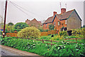
Hampstead Norreys: close to site of former station, 2001
View southward on Water Street, towards Newbury on the long-disused ex-GWR Didcot, Newbury & Southampton line, which all closed to passengers from 10/9/62 and finally on 10/8/64. There seemed to be no trace of the former station ('Hampstead Norris' as spelled), but this was close to where it had been.
Image: © Ben Brooksbank
Taken: 14 May 2001
0.03 miles
5
A place for everything
A place for the cars, a place for the bins. All organised, it needs to be in this crowded street.
Image: © Graham Horn
Taken: 28 Sep 2008
0.04 miles
6
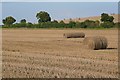
Crop at Hampstead Norreys
All cut, all baled, just awaiting collection.
Image: © Graham Horn
Taken: 28 Sep 2008
0.12 miles
7
Turn right on Water Street
One of the motorcyclists pointing the way for the rest of the group on a Sunday run through Hampstead Norreys.
Image: © Bill Nicholls
Taken: 20 Nov 2011
0.14 miles
8
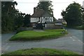
Fiveways
The house is called Fiveways, and there are. The road behind us from Compton, the two roads ahead alternate ways into Hampstead Norreys, a byway to Ilsley to the right and a driveway, possibly an old byway but now private, to the left.
Image: © Graham Horn
Taken: 28 Sep 2008
0.15 miles
9
Church Street and Water Street
Water Street is so named because the River Pang flows beside and occasionally over it.
The name Hampstead Norreys is formed from the generic "hamstede" or homestead and from John Norreys who bought the place in 1450.
Image: © Des Blenkinsopp
Taken: 2 May 2013
0.15 miles
10
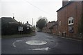
Mini roundabout on the junction
View towards Water Street in Hampstead Norreys with one of those stupid mini roundabouts in the foreground.
Image: © Bill Nicholls
Taken: 20 Nov 2011
0.15 miles