IMAGES TAKEN NEAR TO
South End, PRESTON, PR1 8HA
Introduction
This page details the photographs taken nearby to South End, PR1 8HA by members of the Geograph project.
The Geograph project started in 2005 with the aim of publishing, organising and preserving representative images for every square kilometre of Great Britain, Ireland and the Isle of Man.

There are currently over 7.5m images from over14,400 individuals and you can help contribute to the project by visiting https://www.geograph.org.uk
Image Map
Images are licensed for reuse under creativecommons.org/licenses/by-sa/2.0
Notes
- Clicking on the map will re-center to the selected point.
- The higher the marker number, the further away the image location is from the centre of the postcode.
Image Listing (84 Images Found)
Images are licensed for reuse under creativecommons.org/licenses/by-sa/2.0
Image
Details
Distance
1
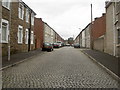
Connaught Road
Cobbles survive in this street off Riverside. (Part of a circular walk around Preston – continues at Image)
Image: © Patrick
Taken: 9 Sep 2007
0.05 miles
2
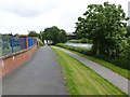
Riverside foot and cycle path
Just west of Avenham Park on the north bank of the Ribble. The lower path forms part of the Guild Wheel, National Cycle Network route 622, a 34 kilometre circular cycle route round Preston which was inaugurated to commemorate the 2012 Preston Guild. The upper path forms part of the Ribble Way, a 117 km long distance path which follows the River Ribble from its source to its mouth.
Image: © Oliver Dixon
Taken: 29 Jun 2013
0.09 miles
3
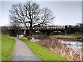
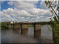
Riverside Walk and The Ribble Viaduct, Preston
Also known as the North Union Railway Bridge, the bridge in the background carries the West Coast Main Line over the River Ribble towards Preston Railway Station. It was originally built 1837-8, for the North Union Railway Company. As the railways expanded, the width of the viaduct was doubled in 1879-80.
It is a grade II listed building (English Heritage Building ID: 392133 http://www.britishlistedbuildings.co.uk/en-392133-railway-viaduct-over-river-ribble-penwor British Listed Buildings).
Image: © David Dixon
Taken: 14 Jan 2015
0.09 miles
4
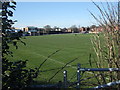
BAC / EE Preston Cricket Club
Working on the pitch at BAC/EE Preston cricket club's Riverside ground.
The club was affiliated to the British Aircraft Corporation / English Electric which became part of British
BAC/EE CC is now run independently and puts four teams into the Palace Shield competition.
Image: © BatAndBall
Taken: 11 Mar 2014
0.10 miles
5
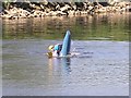
A kayaker pulling a move on the River Ribble
Image: © Iain Robinson
Taken: 10 Jun 2006
0.10 miles
6
The old cobbled bridge over the Ribble
Once a road bridge, now closed to traffic except for cyclists and pedestrians.
Image: © Oliver Dixon
Taken: 29 Jun 2013
0.11 miles
7
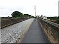
The old cobbled bridge over the River Ribble
Once a road bridge, now closed to traffic except for cyclists and pedestrians.
Image: © Oliver Dixon
Taken: 29 Jun 2013
0.11 miles
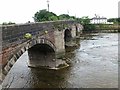
8
Bridges over the Ribble
The nearer bridge was a former railway bridge, now carrying only piping. To the right is Penwortham Bridge which is now closed to vehicular traffic.
Image: © Bill Boaden
Taken: 18 Feb 2012
0.11 miles
9
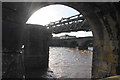
Pipeline across the Ribble
The bridge structure seen from the original Penwortham bridge carries a pipeline across the river.
Image: © Steve Houldsworth
Taken: 13 May 2014
0.11 miles
10
Riverside cottages
These riverside cottages look inviting, but are evidently not selling. Risk of flooding, perhaps? (Part of a circular walk around Preston – continues at Image)
Image: © Patrick
Taken: 9 Sep 2007
0.12 miles