1
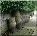
Old Boundary Marker on Beacon Park Road, Plymouth
Municipal Boundary Marker on the north side of Beacon Park Road, Plymouth, against the front garden wall of No. 151. Inscribed D.M.B. (Devonport Municipal Borough) / 4. Devonport borough was established in 1837 following the Municipal Corporations Act 1835.
Milestone Society National ID: DV_DMBB02pb
Image: © T Jenkinson
Taken: 21 Jul 2012
0.03 miles
2
Beacon Park Social Club, Plymouth
Image: © Roger Cornfoot
Taken: 2 Jan 2010
0.06 miles
3
Bungalows, on Beacon Park Road, Plymouth
Image: © Roger Cornfoot
Taken: 2 Jan 2010
0.07 miles
4
Old Boundary Markers on Beacon Park Road, Plymouth
Two boundary markers in Plymouth under a hedge and against a front garden wall on the north side of the junction of Beacon Park Road and Fircroft Road.
On the left is Municipal Boundary Marker DV_DMBB01pb. Inscribed with an upwards pointing arrow and D.M.B. / 5 / 10.S for Devonport Municipal Borough.
On the right is Parish Boundary Marker DV_WPBS01pb. Inscribed WESTON / P for Weston Peverell parish.
Image: © T Jenkinson
Taken: 21 Jul 2012
0.13 miles
5
New flats, on Beacon Park Road
Image: © Roger Cornfoot
Taken: 2 Jan 2010
0.14 miles
6
Uphill, on Beacon Park Road
Image: © Roger Cornfoot
Taken: 2 Jan 2010
0.14 miles
7
Myrtleville, North Prospect - Plymouth
Image: © Mick Lobb
Taken: 1 May 2010
0.16 miles
8
Dingle Road, North Prospect - Plymouth
Following World War I a slum clearance programme began in Plymouth with council housing being constructed in the North Prospect/Swilly area of the town. By 1928 802 council houses had been constructed here.
Despite its leafy avenues the area gained a fierce reputation over the years as one of the poorest and least desirable areas of the town in which to find oneself or to live in. Plymouth City Council is currently planning to redevelop the area, demolishing the existing housing stock and replacing it with modern accommodation. It is likely that more homes will be made available because better use could be made of the land area - that is smaller gardens!
Image: © Mick Lobb
Taken: 1 May 2010
0.19 miles
9
Refurbishment of hospital building - Plymouth
One of the old buildings of the Scott Isolation Hospital undergoing refurbishment. The adjacent site is now a business park so perhaps the building will be converted to business use or even become apartments.
Image: © Mick Lobb
Taken: 1 May 2010
0.21 miles
10
Albion Drive, Plymouth
The road name is a reminder that this area of Beacon Park was for many years the home of Plymouth Albion Rugby Club. The club now plays at the Brickfields in Devonport, and the Beacon Park grounds are given to housing.
Image: © David Smith
Taken: 26 Sep 2014
0.21 miles


