IMAGES TAKEN NEAR TO
Dousland, YELVERTON, PL20 6NA
Introduction
This page details the photographs taken nearby to PL20 6NA by members of the Geograph project.
The Geograph project started in 2005 with the aim of publishing, organising and preserving representative images for every square kilometre of Great Britain, Ireland and the Isle of Man.

There are currently over 7.5m images from over14,400 individuals and you can help contribute to the project by visiting https://www.geograph.org.uk
Image Map
Images are licensed for reuse under creativecommons.org/licenses/by-sa/2.0
Notes
- Clicking on the map will re-center to the selected point.
- The higher the marker number, the further away the image location is from the centre of the postcode.
Image Listing (4 Images Found)
Images are licensed for reuse under creativecommons.org/licenses/by-sa/2.0
Image
Details
Distance
1
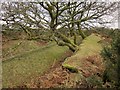
Banks, Yennadon Down
This must be something to do with Yennadon Iron Mine. It's beside a track leading up from Iron Mine Lane onto the down that meets Meavy Footpath 13.
Image: © Derek Harper
Taken: 14 Feb 2015
0.05 miles
2
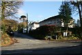
Iron Mine Lane, Dousland
This lane leads up to Yennadon Down where there used to be an old mine.
Image: © Tony Atkin
Taken: 7 Dec 2008
0.12 miles
3
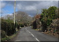
Burrator Road, Dousland
The road is running between houses, but almost nothing can be seen of them; the main pieces of evidence are the walled drive entrances every 25 metres or so on each side.
Image: © Derek Harper
Taken: 5 Mar 2012
0.14 miles
4
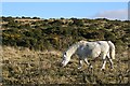
Grazing on Yennadon Down
Yennadon Down is an area of downland between Burrator Reservoir and Dousland. The vegetation is a mixture of grassland and gorse grazed mainly by ponies. The gorse needs to be occasionally burned to keep it down. Once the gorse has been burned the blackened branches often remain for a year or two, as can be seen in the foreground of this photograph.
Image: © Tony Atkin
Taken: 7 Dec 2008
0.23 miles