IMAGES TAKEN NEAR TO
Quant Park, TAVISTOCK, PL19 0JQ
Introduction
This page details the photographs taken nearby to Quant Park, PL19 0JQ by members of the Geograph project.
The Geograph project started in 2005 with the aim of publishing, organising and preserving representative images for every square kilometre of Great Britain, Ireland and the Isle of Man.

There are currently over 7.5m images from over14,400 individuals and you can help contribute to the project by visiting https://www.geograph.org.uk
Image Map
Images are licensed for reuse under creativecommons.org/licenses/by-sa/2.0
Notes
- Clicking on the map will re-center to the selected point.
- The higher the marker number, the further away the image location is from the centre of the postcode.
Image Listing (225 Images Found)
Images are licensed for reuse under creativecommons.org/licenses/by-sa/2.0
Image
Details
Distance
1
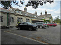
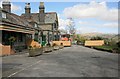
Former railway station, Tavistock
Now converted to accommodation and seen from the public road that ends by the gate to the property. The railway line is now a footpath.
Image: © Chris Allen
Taken: 21 Sep 2021
0.02 miles
2
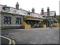
Tavistock: Former Tavistock North railway station
The station was opened in 1890 on the Plymouth Devonport and South Western Junction Railway's line from Plymouth to Lydford where it joined with the London & South Western Railway's line from London. The L&SWR gained running rights on the line to enable them to run trains directly from London to Plymouth in competition with the Great Western Railway.
The station was called Tavistock North to avoid it being confused with the separate Great Western Railway station which was named Tavistock South.
Although the line was closed in 1968, the station, which is constructed of Dartmoor granite, survived, eventually being accorded Grade II listed building status in 1999. In 2007 it was converted into three exclusive self catering accommodation apartments, the website for which is here http://www.oldtavistockrailwaystation.co.uk/index.html
Image: © Nigel Cox
Taken: 6 Oct 2008
0.02 miles
3
Tavistock North Railway Station
Tavistock North Railway Station was completed on 19th July 1889 and was opened to passenger traffic on 2nd June 1890. It served the Plymouth, Devonport & South Western Junction Railway. The Beeching Report took its toll and the last train to use this station was on 6th May 1968. During May 1999 the building became Grade II listed by English Heritage. During May 2008 the building was renovated and remodelled into three holiday houses. More details http://www.oldtavistockrailwaystation.co.uk/history-tavistockrailway/ and http://en.wikipedia.org/wiki/Tavistock_North_railway_station
Image: © Andrew Bodman
Taken: 11 Oct 2014
0.02 miles
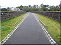
4
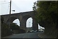
Former railway viaduct over Drake Road
This now carries NCN27 as part of the Devon Coast to Coast route
Image: © David Smith
Taken: 26 Mar 2013
0.05 miles
5
Tavistock, Railway Viaduct
This takes the South Western Junction Railway from Tavistock Station (now self-catering holiday accommodation) across the north of the town. It is now part of National Cycleway Route 27.
Image: © Ian James Cox
Taken: 30 Sep 2009
0.05 miles
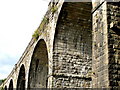
6
Tavistock railway viaduct
The viaduct was opened in 1890 on the Plymouth Devonport and South Western Junction Railway's double track line from Plymouth to Lydford. The tracks were lifted after closure in 1968 and the trackbed now forms a section of the National Cycle Network's Route 27, the Devon Coast to Coast route.
(From a purely Geograph point of view the 248000 Easting gridline crosses the viaduct around its halfway point so this view is looking into Image too.)
Image: © Nigel Cox
Taken: 6 Oct 2008
0.06 miles
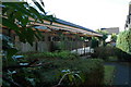
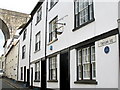
7
Tavistock, Ordulph Arms
Pub on Kilworthy Hill. Internally, L-shaped bar, drinking area to front and right. Cask ales on offer at my visit: Sharp's Doom Bar, St. Austell Tribute. Is currently being refurbished.
Image: © Mike Faherty
Taken: 27 Jul 2010
0.06 miles
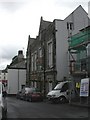
8
Tavistock, Taylor Square
John Taylor designed and built the Tavistock Canal, which runs to Morwellham Quay on the river Tamar. It was in use from 1817 to 1873 to transport copper from the mines on Dartmoor. (The canal today supplies water from the river Tavy to a hydro-electric power station). This is his house in Taylor Square. In the background is the viaduct for the now disused South Western Junction Railway, opened in 1890 and closed in 1968.
Image: © Ian James Cox
Taken: 30 Sep 2009
0.06 miles
9
LSWR former Tavistock North station frontage
Tavistock North shut from May 1968 when the line from Bere Alston to Okehampton was closed. This was on the Plymouth to Exeter railway line and Tavistock North station was sold into private ownership as were most of the stations along this route.
Image: © roger geach
Taken: 4 Apr 2010
0.06 miles
10
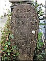
Old Milestone, Old Exeter Road
The milestone is located at the junction with Barley Market Street, east of No. 7, against the end of a wall, on the north west side of the road. Parish of Tavistock (West Devon District). Carved stone post, Tall Tavistock marker design, erected by the Tavistock turnpike trust in the 19th century. For an earlier photograph of the milestone, see https://www.geograph.org.uk/photo/6072348
Inscription reads:-
FROM / LONDON / 215 MILES / OKEHAMPTON / 15 / CALLINGTON / 9 / TRURO 50
Grade II listed, List Entry Number: 1326207 https://historicengland.org.uk/listing/the-list/list-entry/1326207
Milestone Society National ID: DV_TVOK00
Image: © Tim Jenkinson
Taken: 24 Nov 2022
0.07 miles