IMAGES TAKEN NEAR TO
Taylor Square, TAVISTOCK, PL19 0DH
Introduction
This page details the photographs taken nearby to Taylor Square, PL19 0DH by members of the Geograph project.
The Geograph project started in 2005 with the aim of publishing, organising and preserving representative images for every square kilometre of Great Britain, Ireland and the Isle of Man.

There are currently over 7.5m images from over14,400 individuals and you can help contribute to the project by visiting https://www.geograph.org.uk
Image Map
Images are licensed for reuse under creativecommons.org/licenses/by-sa/2.0
Notes
- Clicking on the map will re-center to the selected point.
- The higher the marker number, the further away the image location is from the centre of the postcode.
Image Listing (229 Images Found)
Images are licensed for reuse under creativecommons.org/licenses/by-sa/2.0
Image
Details
Distance
1
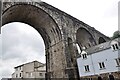
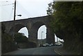
Tavistock Viaduct
Tavistock Viaduct was part of the closed LSWR line from Exeter to Plymouth. This picture is taken from Taylor Square. The line was the London & South Western, later Southern Railway main line to Plymouth, closed in 1968. It has been suggested that this line should be re-opened to provide an alternative route to Plymouth and Cornwall as the old Great Western Railway route from Exeter to Plymouth is now the only access and can be subject to storm damage along the coast around Dawlish.
Image: © Bob Walters
Taken: 29 Jul 2021
0.02 miles
2
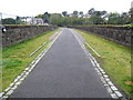
Tavistock railway viaduct
The viaduct was opened in 1890 on the Plymouth Devonport and South Western Junction Railway's double track line from Plymouth to Lydford. The tracks were lifted after closure in 1968 and the trackbed now forms a section of the National Cycle Network's Route 27, the Devon Coast to Coast route.
(From a purely Geograph point of view the 248000 Easting gridline crosses the viaduct around its halfway point so this view is looking into Image too.)
Image: © Nigel Cox
Taken: 6 Oct 2008
0.02 miles
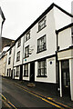
3
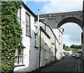
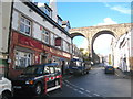
Taylor Square
The viaduct of the former LSWR route from Plymouth via Okehampton to Exeter and on to London (Waterloo) crosses high above the town. These old houses are in Taylor Square. The viaduct is now a permissive path.
Image: © Graham Horn
Taken: 31 May 2011
0.02 miles
4
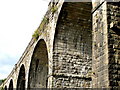
Tavistock, Railway Viaduct
This takes the South Western Junction Railway from Tavistock Station (now self-catering holiday accommodation) across the north of the town. It is now part of National Cycleway Route 27.
Image: © Ian James Cox
Taken: 30 Sep 2009
0.02 miles
5
1 & 2 Taylor Square
Grade II listed early 19th century houses in Taylor Square. Named in recognition of John Taylor (1779-1863), mining entrepreneur and engineer responsible for the construction of the Tavistock Canal.
Image: © Richard Croft
Taken: 8 Sep 2022
0.02 miles
6
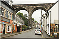
King Street
View up King Street to the former railway viaduct now route 270 of the National Cycle Network
Image: © Richard Croft
Taken: 8 Sep 2022
0.02 miles
7
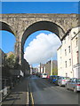
Viaduct on the old LSWR railway
Crossing Bannawell Street. The railway was axed as part of the Beeching cuts and closed in 1968.
Image: © Rod Allday
Taken: 17 Nov 2010
0.02 miles
8
Former railway viaduct, Tavistock
Now a public path. There are good views to be had from the viaduct over the town below.
Image: © Chris Allen
Taken: 21 Sep 2021
0.02 miles
9
Former railway viaduct over Drake Road
This now carries NCN27 as part of the Devon Coast to Coast route
Image: © David Smith
Taken: 26 Mar 2013
0.02 miles
10
The Union Inn
In the background, crossing over Bannawell Street, is Image
Image: © Rod Allday
Taken: 17 Nov 2010
0.03 miles