IMAGES TAKEN NEAR TO
Clitters, CALLINGTON, PL17 8HW
Introduction
This page details the photographs taken nearby to PL17 8HW by members of the Geograph project.
The Geograph project started in 2005 with the aim of publishing, organising and preserving representative images for every square kilometre of Great Britain, Ireland and the Isle of Man.

There are currently over 7.5m images from over14,400 individuals and you can help contribute to the project by visiting https://www.geograph.org.uk
Image Map
Images are licensed for reuse under creativecommons.org/licenses/by-sa/2.0
Notes
- Clicking on the map will re-center to the selected point.
- The higher the marker number, the further away the image location is from the centre of the postcode.
Image Listing (15 Images Found)
Images are licensed for reuse under creativecommons.org/licenses/by-sa/2.0
Image
Details
Distance
1
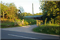
Farm buildings, Downgate
The entrance to farm buildings off the B3257 at Downgate, near Callington, Cornwall.
Image: © Kevin Hale
Taken: 1 Jun 2006
0.04 miles
2
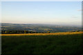
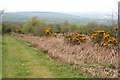
View from Downgate
The view from near Downgate, Cornwall, looking towards Dartmoor on a hazy summer evening.
Image: © Kevin Hale
Taken: 1 Jun 2006
0.08 miles
3
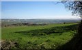
Towards Dartmoor
Looking to the right from the gateway shown in Image], with the moor on the horizon.
Image: © Derek Harper
Taken: 20 Apr 2015
0.08 miles
4
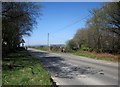
Junction on the B3257
With a side road to Downgate on the right, the start of the Tamar Valley Discovery Trail. This is beside the entrance to a car park at the foot of Kit Hill inclined plane Image
Image: © Derek Harper
Taken: 20 Apr 2015
0.13 miles
5
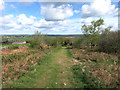
Heathland Vegetation by the Inclined Plane
On the northern slope of Kit Hill looking down the inclined plane which was used to transport granite from the quarry above.
Image: © Tony Atkin
Taken: 20 Apr 2009
0.13 miles
6
Stoke Climsland: foot of Kit Hill inclined plane
The first inclined plane here was constructed in 1872. It brought granite from quarries near the summit of Kit Hill to the sidings at Downgate, on the East Cornwall Mineral Railway; the granite was then taken via a second incline at Calstock to quays on the Tamar. The incline was modified in the early 20th century, with the rail gauge changed from 3' 6" to 4' 8½" and the Calstock incline was replaced with a wagon lift at the side of the new Calstock viaduct. The line here finally closed in 1955. Kit Hill granite was used in six crossings of the Thames in London and for the Bishop Rock lighthouse
Image: © Martin Bodman
Taken: 27 Aug 2010
0.14 miles
7
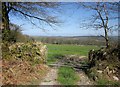
Countryside near Stoke Climsland
Looking through a gateway across the B3257 from Image Somewhere out there the Tamar cuts across the landscape in a deep wooded valley.
Image: © Derek Harper
Taken: 20 Apr 2015
0.14 miles
8
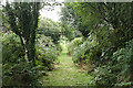
Entrance to Kit Hill
Most people get onto Kit Hill via the road on the eastern side of the hill which takes you up to the top. This is the far less used and more interesting northern entrance to the hill. Here the only way to the top is to walk or ride a horse.
Image: © Tony Atkin
Taken: 20 Apr 2009
0.15 miles
9
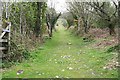
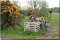
The Bottom of the Inclined Plane on Kit Hill
Kit Hill quarry was situated near the top of the hill and stone lowered down this inclined plane in rail wagons. Here at the bottom there were sidings and a link to the railway running along the edge of Kit Hill. Now this inclined plane is a quick way to walk to the top of the hill.
Image: © Tony Atkin
Taken: 20 Apr 2009
0.15 miles
10
Kit Hill Incline
One of many reminders of the former mining and quarrying industries on Kit Hill.
Now one of the access routes into Kit Hill Country Park.
Image: © Des Blenkinsopp
Taken: 28 Apr 2015
0.18 miles