IMAGES TAKEN NEAR TO
Trerulefoot, SALTASH, PL12 5BL
Introduction
This page details the photographs taken nearby to PL12 5BL by members of the Geograph project.
The Geograph project started in 2005 with the aim of publishing, organising and preserving representative images for every square kilometre of Great Britain, Ireland and the Isle of Man.

There are currently over 7.5m images from over14,400 individuals and you can help contribute to the project by visiting https://www.geograph.org.uk
Image Map
Images are licensed for reuse under creativecommons.org/licenses/by-sa/2.0
Notes
- Clicking on the map will re-center to the selected point.
- The higher the marker number, the further away the image location is from the centre of the postcode.
Image Listing (65 Images Found)
Images are licensed for reuse under creativecommons.org/licenses/by-sa/2.0
Image
Details
Distance
1
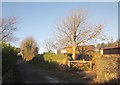
Lane at Trerulefoot
Looking in other direction from Image], up the lane to Trerule Hillhead. The sign offers "Xmas trees from £20" at Dave's Sheds.
Image: © Derek Harper
Taken: 30 Nov 2013
0.03 miles
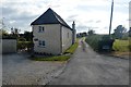
2
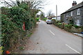
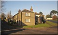
Minor road
Just off the A374, this road leads to Bake Manor a mile or so away. The houses on the right are part of Trerulefoot.
Image: © jeff collins
Taken: 3 Dec 2013
0.03 miles
3
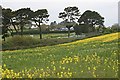
Towards Trerulefoot
Looking across a field of oilseed rape, railway line, pine trees and one of the roads which meet at Trerulefoot junction.
Image: © Tony Atkin
Taken: 13 May 2006
0.05 miles
5
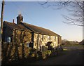
Cottage, Trerulefoot
Image: © Derek Harper
Taken: 30 Nov 2013
0.05 miles
6
Cottage, Trerulefoot
The slate-hung Trerule Farm Cottage is shown from the other direction in Image Beyond, the lane meets the A374.
Image: © Derek Harper
Taken: 30 Nov 2013
0.05 miles
7
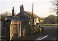
Cottage, Trerulefoot
The eastern end of the cottage shown in Image], with the lane to Trerule Hillhead on the left and the A374 reaching the roundabout on the right.
Image: © Derek Harper
Taken: 30 Nov 2013
0.05 miles
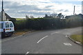
8
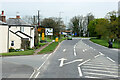
Trerulefoot, A374
Trerulefoot is a village in southeast Cornwall, located approximately halfway between the towns of Saltash and Liskeard. The village has a farm shop, two cafés and a petrol filling station.
Image: © David Dixon
Taken: 15 Apr 2022
0.05 miles
10
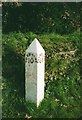
Old Milepost by the A374, Trerulefoot
Cast iron post by the A374, in parish of ST GERMANS (CARADON District), Trerulefoot, by Kernow Mill shopping centre, against stone wall, on North side of road. Torpoint iron spear, erected by the Liskeard turnpike trust in the 19th century.
Inscription reads:-
: TORPOINT / 10 : : LISKEARD / 6½ :
Grade II Listed. List Entry Number:1140535
https://historicengland.org.uk/listing/the-list/list-entry/1140535
Milestone Society National ID: CW_TPLK10.
Image: © Ian Thompson
Taken: 1 Nov 2001
0.06 miles