IMAGES TAKEN NEAR TO
Manor Gardens, TORPOINT, PL10 1PR
Introduction
This page details the photographs taken nearby to Manor Gardens, PL10 1PR by members of the Geograph project.
The Geograph project started in 2005 with the aim of publishing, organising and preserving representative images for every square kilometre of Great Britain, Ireland and the Isle of Man.

There are currently over 7.5m images from over14,400 individuals and you can help contribute to the project by visiting https://www.geograph.org.uk
Image Map (Loading...)


Getting Data...Please wait
Leaflet Map data © OpenStreetMap
Images are licensed for reuse under creativecommons.org/licenses/by-sa/2.0
Notes
- Clicking on the map will re-center to the selected point.
- The higher the marker number, the further away the image location is from the centre of the postcode.
Image Listing (9 Images Found)
Images are licensed for reuse under creativecommons.org/licenses/by-sa/2.0
Image
Details
Distance
1

To Insworke Barton
Insworke Barton is the ruined farm in the centre, no the northern edge of Millbrook. This view looks right from the same place as Image], with a distant view of Plymouth on the right.
Image: © Derek Harper
Taken: 11 May 2019
0.07 miles
2

Millbrook
This photograph was taken from the viewpoint on Maker Heights overlooking the village (SX430516)
Image: © Tony Atkin
Taken: 12 Aug 2005
0.18 miles
3
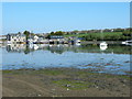
Millbrook boatyard
The boatyard nearest to the dam at Millbrook, with the creek nearly at high tide and brilliant sunshine it is ideal for reflections.
Image: © Jay Pea
Taken: 6 May 2018
0.18 miles
4
Insworke Barton
View across head of estuary to buildings marked on area of map called, Insworke Barton'.
Image: © BB
Taken: 25 Feb 2007
0.18 miles
5

Devonport from near Millbrook, Cornwall
Contrasting rural landscape on the Torpoint side of the Tamar
Image: © Crispin Purdye
Taken: Unknown
0.18 miles
6

Tidal Creek
Sunset at Millbrook looking across the tidal creek
Image: © roger geach
Taken: 28 Nov 2012
0.22 miles
7

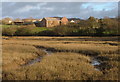
Lake, Millbrook
"The Lake was created when the tidal creek was dammed in 1981, following regular flooding of the village in the 1970’s ... a sluice in the dam prevents the lake from over filling" http://www.millbrook-pc.gov.uk/village-amenities/lake-park/ .
Image: © Derek Harper
Taken: 11 May 2019
0.22 miles
8

Millbrook Freshwater Lake
As distinguished from the tidal inlet called Millbrook Lake, which lies to the east of the dam creating the lake seen here.
Image: © Trevor Harris
Taken: 4 Apr 2017
0.24 miles
9

Southdown Terrace
Part of a terrace of six on Southdown Road, looking behind the camera in Image
Image: © Derek Harper
Taken: 11 May 2019
0.25 miles