IMAGES TAKEN NEAR TO
New Road, TORPOINT, PL10 1PA
Introduction
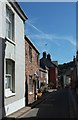
This page details the photographs taken nearby to New Road, PL10 1PA by members of the Geograph project.
The Geograph project started in 2005 with the aim of publishing, organising and preserving representative images for every square kilometre of Great Britain, Ireland and the Isle of Man.

There are currently over 7.5m images from over14,400 individuals and you can help contribute to the project by visiting https://www.geograph.org.uk
Image Map
Images are licensed for reuse under creativecommons.org/licenses/by-sa/2.0
Notes
- Clicking on the map will re-center to the selected point.
- The higher the marker number, the further away the image location is from the centre of the postcode.
Image Listing (215 Images Found)
Images are licensed for reuse under creativecommons.org/licenses/by-sa/2.0
Image
Details
Distance
1
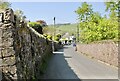
Barracks Road
The road closed signs are temporarily removed for the May bank holidays in the village.
Image: © Jay Pea
Taken: 7 May 2018
0.03 miles
2
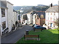
The Green, Kingsand
The Green at Kingsand with the Rising Sun Inn on the right and Cawsand Fort in the distance
Image: © Darren Rosson
Taken: 5 Feb 2007
0.06 miles
3
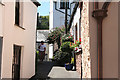
Maker with Rame: Kingsand
Little Lane
Image: © Martin Bodman
Taken: 18 Jul 2007
0.07 miles
4
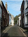
Fore Street - middle section
A view of the middle section of Fore Street in Kingsand between Little Lane and Green Lane, looking northwards.
Image: © Rob Farrow
Taken: 25 Jan 2014
0.08 miles
5
Fore Street, Kingsand
Looking down the street from the village store.
Image: © Derek Harper
Taken: 8 Aug 2015
0.08 miles
6
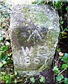
Old Boundary Marker
War Department Boundary Marker on the east slope of Wringford Down to the north west of Cawsand Fort. MAKER WITH RAME parish. Inscribed ↑ / W D / 1867. The marker is on the boundary of the former Cawsand Fort.
Milestone Society National ID: CW_WDCAW02em
Image: © R Hanns
Taken: 27 Oct 2019
0.08 miles
7
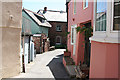
Maker with Rame: Kingsand
Street in the village
Image: © Martin Bodman
Taken: 18 Jul 2007
0.09 miles
8
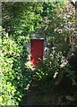
Red door, Kingsand
Seen from footpath 617 28/1, but not on it. The tiny path climbs round the north end of the village to meet Devonport Hill.
Image: © Derek Harper
Taken: 8 Aug 2015
0.09 miles
9
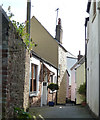
Little Lane, Kingsand - view eastwards
The appropriately named "Little Lane" links Fore Street to Market Street in Kingsand. For the complementary view see Image]
Image: © Rob Farrow
Taken: 10 Apr 2012
0.09 miles
10
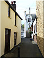
Little Lane, Kingsand - view westwards
The complememntary photo to Image], looking down Little Lane in Kingsand westwards from Market Street through to Fore Street.
Image: © Rob Farrow
Taken: 10 Apr 2012
0.09 miles