IMAGES TAKEN NEAR TO
Home Farm Steading, Erskine Ferry Road, BISHOPTON, PA7 5DF
Introduction
This page details the photographs taken nearby to Home Farm Steading, Erskine Ferry Road, PA7 5DF by members of the Geograph project.
The Geograph project started in 2005 with the aim of publishing, organising and preserving representative images for every square kilometre of Great Britain, Ireland and the Isle of Man.

There are currently over 7.5m images from over14,400 individuals and you can help contribute to the project by visiting https://www.geograph.org.uk
Image Map
Images are licensed for reuse under creativecommons.org/licenses/by-sa/2.0
Notes
- Clicking on the map will re-center to the selected point.
- The higher the marker number, the further away the image location is from the centre of the postcode.
Image Listing (21 Images Found)
Images are licensed for reuse under creativecommons.org/licenses/by-sa/2.0
Image
Details
Distance
2
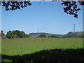
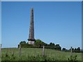
Monument near Bishopton
The Blantyre Monument in a field adjacent to Ferry Road on the way to Erskine, is in memory of Robert Walter Stewart, 11th Lord Blantyre, who lived at nearby Erskine House. A Major-General in the British Army, he served with the Duke of Wellington in the Napoleonic Wars. He survived the Peninsular campaign in Spain and Portugal where he displayed great bravery, but was accidentally killed by a stray bullet while caught in a street riot in Brussels in 1830. Held in high esteem by friends and colleagues who erected the towering monument in his memory.
Image: © Stephen Sweeney
Taken: 28 May 2007
0.18 miles
3
Erskine Home Farm
The right honourable Robert Walter 11th lord Blantyre monument stands in farm land that leads to the Ersking Home Farm on Ferry Rd.
Image: © david cameron photographer
Taken: 15 Jul 2015
0.19 miles
4
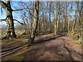
Path around Big Wood
The path is the one shown in Image, but the present view is from about 180 metres further along it.
At the time of writing, the 1:25000 map does show a path near the edge of Big Wood; it is close to the path I was following, but the latter is nearer the edge of the woods, as the picture shows.
Image: © Lairich Rig
Taken: 27 Mar 2017
0.19 miles
5
Robert Walter 11th lord Blantyre Bishopton
Erected by the county of Renfrew to the memory of the right honourable Robert Walter 11th lord Blantyre.
A major general in the British army and formerly lord lieutenant of Renfrewshire.
In testimony of respect for his public services and as a tribute of esteem of his private worth
Other images you'll find on my flicker page https://www.flickr.com/photos/its-all-pretty-cool_dot-com/sets/72157655930835472
Image: © david cameron photographer
Taken: 15 Jul 2015
0.20 miles
6
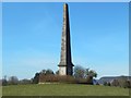
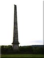
Monument to Lord Blantyre
Specifically, the monument commemorates Robert Walter Stuart, the 11th Lord Blantyre. He died on the 22nd of September 1830: he was shot when he looked out from an upper window of a hotel in Brussels, during what later came to be known as the Belgian Revolution.
As the New Statistical Account (1845) observes, "he was Lord Lieutenant of Renfrewshire, and was so highly esteemed by the gentlemen of that county that, shortly after his death, they erected, on a conspicuous situation on his estate of Erskine, an elegant column in the form of an obelisk, as a tribute of respect to his memory."
The obelisk is about 80 feet high, and it was erected within a few years of Lord Blantyre's death. The architect was William Burn, who had been a pupil of Robert Smirke (the architect of nearby Erskine House, which was built for Lord Blantyre, though his untimely death meant that he would not live to enjoy it).
For the inscription, see Image and Image
For other views of the monument as a whole, see Image, Image and Image
Charles Walter Stuart, son of Robert Walter Stuart, became the 12th Lord Blantyre, but the title became extinct on his death; he had been predeceased by his only son. The family were originally of the Stuarts (or Stewarts) of Minto; the first Lord Blantyre was Walter Stuart, elevated to the peerage in 1606. See discussion at Image
(The OS grid line almost coincides with the north face of the obelisk; most or all of the monument is therefore in the same grid square as the photographer, as is most of its surrounding enclosure.)
Image: © Lairich Rig
Taken: 27 Mar 2017
0.20 miles
7
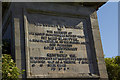
Monument to Lord Blantyre: inscription
For the obelisk as a whole, and for further information, see Image and other images linked from there. The inscription (with missing parts filled in) is as follows; note that his date of death is usually given as the 22nd, although this inscription does give the date as the 23rd (the digit "3" is intact):
"ERECTED
BY
THE COUNTY OF RENFREW
TO
THE MEMORY OF
THE RIGHT HONOURABLE ROBERT WALTER,
11ᵀᴴ LORD BLANTYRE,
A MAJOR GENERAL IN THE BRITISH ARMY,
AND FORMERLY
LORD LIEUTENANT
OF RENFREWSHIRE,
IN TESTIMONY OF RESPECT FOR HIS PUBLIC
SERVICES, AND AS A TRIBUTE OF ESTEEM
FOR HIS PRIVATE WORTH
DIED 23ᴰ SEPT 1830".
Image: © Lairich Rig
Taken: 27 Mar 2017
0.20 miles
8
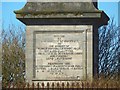
Monument to Robert Walter, 11th Lord Blantyre
The 1:50000 scale Landranger map shows the monument to be in square NS4472 whereas the 1:25000 scale Explorer map shows it in square NS4471. The Explorer map is shown to be correct by the satellite mapping of Geograph.
The inscription on the monument reads: Erected by the county of Renfrew to the memory of the Right Honourable Robert Walter, 11th Lord Blantyre, a major general in the British Army and formerly Lord Lieutenant of Renfrewshire in testimony of respect for his public services and as a tribute of esteem for his private worth.
The last line of the inscription gave a date but this is no longer decipherable.
Image: © G Laird
Taken: 17 Dec 2013
0.20 miles
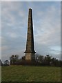
9
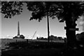
Blantyre Monument
Typical early 19th century monument, in this case a Major-General Robert Walter Stuart who fought with Wellington.
Image: © Richard Webb
Taken: 2 Jun 2016
0.20 miles
10
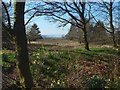
View from the edge of Big Wood
The view is from the vicinity of the bench shown in Image Followed clockwise around Big Wood, the path, up to about this point, is beside a field, but here it is near a part of the golf course of Erskine Golf Club.
What can be seen, in increasing order of distance, is: the edge of Big Wood, a part of the golf course, and the Firth of Clyde near the mouth of the Holy Loch. The dip at the right-hand side of the visible part of the skyline that can be seen in the gap, in this picture, is located there. A small bare tree stands in front of that dip.
The New Statistical Account (1845), in its description of Erskine Parish, says that the chain of hills around the Holy Loch was, when viewed from the Bishopton area, known by a local name, "the Farrel of Cakes"(*), on account of the peculiar shape of those hills.
[(*) That probably needs some explaining for modern readers. "Farrel" is a variant of the more usual "Farl", a word that referred to a quarter slice of a bannock (or of a scone, or shortbread, or similar items); expressions like "a farl o' cakes" or "a farl o' scones" were then in common use. The general idea of the old place-name is (I suppose) that the hills project towards one another in a way that reminded people of slices of cake arranged in a group.]
Image: © Lairich Rig
Taken: 27 Mar 2017
0.20 miles