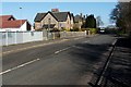
IMAGES TAKEN NEAR TO
Glenburn Road, PAISLEY, PA2 8TJ
Introduction
This page details the photographs taken nearby to Glenburn Road, PA2 8TJ by members of the Geograph project.
The Geograph project started in 2005 with the aim of publishing, organising and preserving representative images for every square kilometre of Great Britain, Ireland and the Isle of Man.

There are currently over 7.5m images from over14,400 individuals and you can help contribute to the project by visiting https://www.geograph.org.uk
Image Map
Images are licensed for reuse under creativecommons.org/licenses/by-sa/2.0
Notes
- Clicking on the map will re-center to the selected point.
- The higher the marker number, the further away the image location is from the centre of the postcode.
Image Listing (38 Images Found)
Images are licensed for reuse under creativecommons.org/licenses/by-sa/2.0
Image
Details
Distance
1
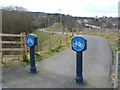
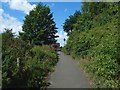
Paisley South Cycle Route
When the photo was taken, this fairly short section of cycle path had only recently been completed. It is a little over 1 km in length, linking Image (from which the photo was taken) with Braehead Road; however, it is the first stage of a longer Paisley South Cycle Route.
For a later view of the same access point, see Image, which includes further information. When that latter picture was taken, there was also a corresponding section of the cycle route leading away from the opposite side of Glenfield Road: Image
Image: © Lairich Rig
Taken: 18 Mar 2008
0.04 miles
2
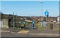
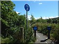
Paisley South Cycle Route
The same access point is shown in an earlier photograph: Image It is located alongside Image, and appears in that photograph.
This part of the route runs through a grassy area between Image to the south (left) and Glenburn Road to the north. Some of the houses alongside the latter road can be seen directly behind the two short blue posts of the entrance.
For a view from 960 metres further along the cycle path, in this direction, see Image
By the time the present photograph was taken, there was a similar access point, almost facing this one, on the other side of the Glenfield Road (they are staggered by 20 metres or so): Image
The part of the cycle route that is shown in the present photograph runs very close to, but does not quite follow, the former course of a railway line.
For an idea of how this view appears in different weather conditions, see the following, which was taken (though not by me) one month later: Image
Image: © Lairich Rig
Taken: 28 Feb 2011
0.05 miles
3
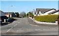
Glenfield Avenue
The photograph was taken from the junction with Glenfield Road; that road appears in the foreground (see Image, which also shows the junction from which the present picture was taken).
Not far ahead, on the left, is the junction with Glenfield Crescent.
Image: © Lairich Rig
Taken: 28 Feb 2011
0.06 miles
4
Paisley South Cycle Route
Entrance from Glenfield Road.
Image: © wfmillar
Taken: 29 Mar 2011
0.07 miles
5
Paisley South Cycle Route
This is a view to the point, about 30 metres ahead, where the path meets Glenfield Road: Image
Image: © Lairich Rig
Taken: 9 Aug 2018
0.08 miles
6
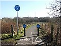
Paisley South Cycle Route
This access point from Glenfield Road is shown in a different season in an earlier picture: Image This section of it runs just to the north of Thornley Dam. See Image for a view back to this point from about 30 metres ahead.
Image: © Lairich Rig
Taken: 9 Aug 2018
0.09 miles
7
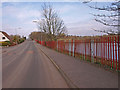
Glenfield Road, Paisley
Thornley Dam on the right.
Image: © wfmillar
Taken: 29 Mar 2011
0.09 miles
8
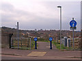
Paisley South Cycle Route
The photograph was taken from Glenfield Road, and shows one access point of the cycle route. See Image for a view of it in a different season.
Another access point almost faces this one, on the opposite side of the road: Image; see that item for more information.
In the present photograph, the former course of a railway line intersects the cycle route at this access point. However, the cycle route immediately veers away slightly from that route, running just to its south. Further ahead, the two routes again coincide: Image
Image: © Lairich Rig
Taken: 28 Feb 2011
0.09 miles
9

Glenfield Road
This is the same road as shown in Image, but the present photograph is a view in the opposite direction; in addition, it was taken from a point about 20 metres further to the SSW, so as to cross an intervening OS grid line.
Not far ahead on the right is the junction with Image (from the pavement opposite that junction, I took a picture of Image). Further ahead, Glenfield Road curves out of sight, to the right; for a view around that corner, see Image
Image: © Lairich Rig
Taken: 28 Feb 2011
0.10 miles
10
Glenfield Road
At the end of the road (150 metres ahead, where a van is parked), is the junction with Caplethill Road.
Visible not far ahead, on the left, is one of the access points to a cycle route; that access point is shown in Image and in Image
For a view along the same road in the opposite direction, see Image
Image: © Lairich Rig
Taken: 28 Feb 2011
0.10 miles