IMAGES TAKEN NEAR TO
Laxlie Drive, GREENOCK, PA16 0FQ
Introduction
This page details the photographs taken nearby to Laxlie Drive, PA16 0FQ by members of the Geograph project.
The Geograph project started in 2005 with the aim of publishing, organising and preserving representative images for every square kilometre of Great Britain, Ireland and the Isle of Man.

There are currently over 7.5m images from over14,400 individuals and you can help contribute to the project by visiting https://www.geograph.org.uk
Image Map
Images are licensed for reuse under creativecommons.org/licenses/by-sa/2.0
Notes
- Clicking on the map will re-center to the selected point.
- The higher the marker number, the further away the image location is from the centre of the postcode.
Image Listing (521 Images Found)
Images are licensed for reuse under creativecommons.org/licenses/by-sa/2.0
Image
Details
Distance
1
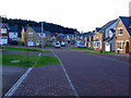
Commoncraig
New houses on the site of Hill Farm, south of Inverkip railway station where the station footbridge can be seen. Commoncraig is the wooded area in the middle distance.
Compare with the same view in July 2007 Image
Image: © Thomas Nugent
Taken: 30 Apr 2018
0.03 miles
2
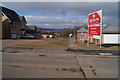
New houses at Inverkip
The houses on the right are built on what was the garden of Inverkip House, which stood behind the trees, on the other side of the railway line. The footpath leading away from the photographer follows the line of an old footpath which ran through the field to the railway footbridge to Beatock Place.
Image: © Thomas Nugent
Taken: 13 Mar 2010
0.03 miles
3
New houses at Inverkip
On land that was designated greenbelt until Inverclyde Council agreed to a controversial land swap deal with the developers. The railway footbridge at the end of Beatock Place can just be seen through the trees to the right.
Image: © Thomas Nugent
Taken: 13 Mar 2010
0.03 miles
4
Building site at Hill Farm
With snow capped Cowal Hills in the distance across the Clyde. A similar view to Image
Image: © Thomas Nugent
Taken: 5 Dec 2008
0.03 miles
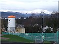
5
Hill Farm housing Development
On former greenbelt land, south of the railway line at Inverkip. The railway is behind the houses on the right. Berfern Plantation is behind the houses on the left. There are no street signs in place yet.
Image: © Thomas Nugent
Taken: 22 Nov 2010
0.04 miles
6
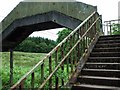
Footbridge at Beatock Place
Crosses the railway line just east of Inverkip station. Looking in a sad state of repair. At the time of writing (March 2009) the bridge is closed while building works take place in the field in the background.
Image: © Thomas Nugent
Taken: 17 Jun 2007
0.04 miles
7
Railway footbridge at Inverkip
Closed during construction of houses in the former greenbelt Fields 7, 8 & 9. The bridge crosses the Glasgow to Wemyss Bay line to the east of Inverkip station.
Image: © Thomas Nugent
Taken: 22 Nov 2010
0.04 miles
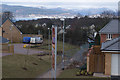
8
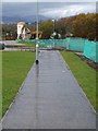
New footpath
Runs along the line of the old "Jacob's Ladder" footpath, south of the railway line. Part of the railway footbridge is visible beyond the second lamppost.
See the same scene in August 2007 here Image
Image: © Thomas Nugent
Taken: 7 Nov 2008
0.04 miles
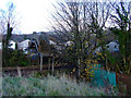
9
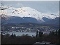
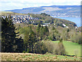
Kirn and the River Clyde from Inverkip
Viewed over the rooftops of the new houses at Finnockbog Road. The hill in the background is Beinn Mhor, near Lock Eck.
Image: © Thomas Nugent
Taken: 5 Dec 2008
0.04 miles
10
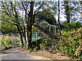
Footbridge at Beatock Place
The footbridge, which crosses the Glasgow to Wemyss Bay railway line, is currently closed while house building takes place.
Image: © Thomas Nugent
Taken: 7 Oct 2011
0.04 miles