IMAGES TAKEN NEAR TO
OX6 0JF
Introduction
This page details the photographs taken nearby to OX6 0JF by members of the Geograph project.
The Geograph project started in 2005 with the aim of publishing, organising and preserving representative images for every square kilometre of Great Britain, Ireland and the Isle of Man.

There are currently over 7.5m images from over14,400 individuals and you can help contribute to the project by visiting https://www.geograph.org.uk
Image Map
Images are licensed for reuse under creativecommons.org/licenses/by-sa/2.0
Notes
- Clicking on the map will re-center to the selected point.
- The higher the marker number, the further away the image location is from the centre of the postcode.
Image Listing (37 Images Found)
Images are licensed for reuse under creativecommons.org/licenses/by-sa/2.0
Image
Details
Distance
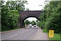
1

Bicester, Launton Road railway bridge
1968 Ordnance Survey cut mark benchmark on the abutment wall of the railway bridge over Launton Road. The mark was levelled at 70.91m above Newlyn datum. For additional information on this and neighbouring benchmarks see http://www.bench-marks.org.uk/bm34170
Image: © Roger Templeman
Taken: 28 Apr 2010
0.03 miles
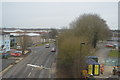
2
Bicester
Launton Road. The railway bridge carries the main line from Marylebone to Banbury and beyond.
Image: © Peter Trimming
Taken: 5 Jun 2018
0.04 miles
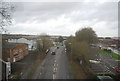
3

Railway bridge over Launton Road
The railway is one of the things that has traditionally given Bicester its standing.
Image: © Bill Boaden
Taken: 26 Jun 2015
0.05 miles
4

Aldi, Bicester
Built on a former industrial site.
Image: © Bill Boaden
Taken: 26 Jun 2015
0.06 miles
5

Launton Road, Bicester
Looking NNE along Launton Road from the railway bridge.
Image: © David P Howard
Taken: 13 Apr 2014
0.07 miles
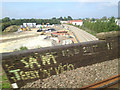
8
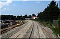
Railway construction area in Bicester
The line from Oxford to Bicester is being twin lined to take trains to London Marylebone. This section will be part of the East West Rail Project that will connect East Anglia with the South and West of England.
The area on the left is where the Bicester Chord is being constructed to connect to the Birmingham Snow Hill to London Marylebone line.
Image: © Steve Daniels
Taken: 23 Jun 2014
0.08 miles
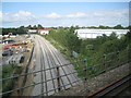
9
Railway construction northeast of Bicester, 23 July 2014
The immediate view, from a London-bound Chiltern Railways train, is of the site of a new rail link between Bicester Town station and the Chiltern Line. It will allow Chiltern to run services between Marylebone and Oxford. In railway circles, I understand, this link is called the Bicester Chord. On the right is the new clean dual track of the line from Oxford to Bletchley. This view is roughly the reverse of Image
The bigger picture is that this is part of the EastWest Rail Project to connect East Anglia with central, southern and western England http://www.eastwestrail.org.uk Thanks to Andrew Bodman for information. He is photographing other parts of the undertaking http://www.geograph.org.uk/search.php?i=51155856
Image: © Robin Stott
Taken: 23 Jul 2014
0.08 miles
10
Railway construction northeast of Bicester, 3 August 2014
The main subject is the clean, newly dualled line from Oxford to Bletchley. This view is roughly the reverse of Image The bigger picture is that this is part of the EastWest Rail Project to connect East Anglia with central, southern and western England http://www.eastwestrail.org.uk Thanks to Andrew Bodman for information. He is photographing other parts of the undertaking http://www.geograph.org.uk/search.php?i=51155856
On the left is the site of a new rail link between Bicester Town station and the Chiltern Line. It will allow Chiltern to run services between Marylebone and the new Oxford Parkway station by the A34. In railway circles, I understand, this link is called the Bicester Chord. The view is from a Chiltern Railways service from Birmingham to London.
Image: © Robin Stott
Taken: 3 Aug 2014
0.09 miles