IMAGES TAKEN NEAR TO
Middle Street, KIDLINGTON, OX5 2SE
Introduction
This page details the photographs taken nearby to Middle Street, OX5 2SE by members of the Geograph project.
The Geograph project started in 2005 with the aim of publishing, organising and preserving representative images for every square kilometre of Great Britain, Ireland and the Isle of Man.

There are currently over 7.5m images from over14,400 individuals and you can help contribute to the project by visiting https://www.geograph.org.uk
Image Map
Images are licensed for reuse under creativecommons.org/licenses/by-sa/2.0
Notes
- Clicking on the map will re-center to the selected point.
- The higher the marker number, the further away the image location is from the centre of the postcode.
Image Listing (102 Images Found)
Images are licensed for reuse under creativecommons.org/licenses/by-sa/2.0
Image
Details
Distance
3
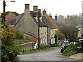
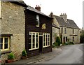
Cottages in High Street, Islip
Looking towards the junction of Middle Street (left) and Kings Head Lane (centre).
Image: © David Kemp
Taken: 17 Jul 2010
0.03 miles
4

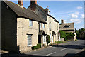
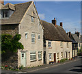
Houses on the walk, Islip
These were a row of three cottages, the one in the middle is now part of the one on the right.
Image: © David Howard
Taken: 21 Jan 2020
0.04 miles
5
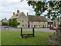
The Green, Islip
The house with the facing gable dates from the late 17th or early 18th century, and is of local limestone with a traditional stone slate roof, which appears to have been recently renewed. There is a sundial in the gable which is dated 1776. The house to the right, now divided into two dwellings, is of similar period. Both are Listed Grade II. In the foreground are the village stocks.
Image: © Alan Murray-Rust
Taken: 3 Jul 2014
0.04 miles
6
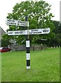
Old Direction Sign - Signpost by the B4027, Church Square, Islip
No finial - 3 arms; Oxon. Wood by the UC road, in parish of Islip (Cherwell District), Church Square, junction with High Street, Middle Street, Cross Tree, on green.
Surveyed
Milestone Society National ID: OX_SP5214
Image: © Alan Rosevear
Taken: 7 Jun 2014
0.05 miles
7
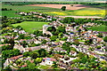
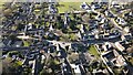
Aerial view of Islip, Oxfordshire
Taken from the South-East, the Red Lion Pub is lower left, and St Nicholas' Church in the centre of the photo with children's playground and playing field lying behind.
Image: © Dave Price
Taken: 2 Jun 2013
0.05 miles
9
Kings Head House, Islip
The name of the house is the clue to its former existence as the Kings Head pub. Parts of the building date back to possibly the late 16th century, although remodelling took place in later centuries, including this gable end. Listed Grade II.
Image: © Alan Murray-Rust
Taken: 3 Jul 2014
0.05 miles
10
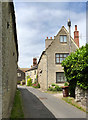
Kings Head Street, Islip
Taken at the junction with Middle Street (left).
Image: © David Kemp
Taken: 17 Jul 2010
0.05 miles