IMAGES TAKEN NEAR TO
Turner View, OXFORD, OX3 8GG
Introduction
This page details the photographs taken nearby to Turner View, OX3 8GG by members of the Geograph project.
The Geograph project started in 2005 with the aim of publishing, organising and preserving representative images for every square kilometre of Great Britain, Ireland and the Isle of Man.

There are currently over 7.5m images from over14,400 individuals and you can help contribute to the project by visiting https://www.geograph.org.uk
Image Map
Images are licensed for reuse under creativecommons.org/licenses/by-sa/2.0
Notes
- Clicking on the map will re-center to the selected point.
- The higher the marker number, the further away the image location is from the centre of the postcode.
Image Listing (13 Images Found)
Images are licensed for reuse under creativecommons.org/licenses/by-sa/2.0
Image
Details
Distance
1
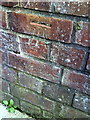
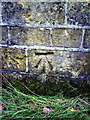
Benchmark on the side wall of #17 Waynflete Road
Ordnance Survey cut mark benchmark described on the Bench Mark Database at http://www.bench-marks.org.uk/bm37452
Image: © Roger Templeman
Taken: 28 Mar 2011
0.10 miles
2
Watermill Way, Sandhills
Down the end of this road on the Bayswater Brook, Bayswater Mill is shown on the map.
Image: © Des Blenkinsopp
Taken: 3 Feb 2020
0.13 miles
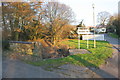
3
Old and new Bayswater Bridges
The road on the left is Bayswater Road, on the right is the entrance to the Bayswater Mill estate.
Image: © Roger Templeman
Taken: 28 Mar 2011
0.16 miles
4
Benchmark on eastern parapet of the old Bayswater Bridge
This Ordnance Survey cut mark benchmark which is on the old bridge of Image is described on the Bench Mark Database at http://www.bench-marks.org.uk/bm37444
Image: © Roger Templeman
Taken: 28 Mar 2011
0.16 miles
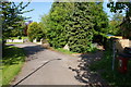
5
Entrance to Bayswater Mill and old bridge over Bayswater Brook
There is an OS benchmark Image near the left hand end of the bridge parapet
Image: © Roger Templeman
Taken: 27 Feb 2019
0.16 miles
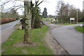
6
Bayswater Farm Road
A quiet access road though much of the farmland has now been given over to housing. I was offered a UKIP election leaflet on this road.
Image: © Bill Boaden
Taken: 3 May 2014
0.17 miles
7
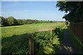
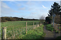
Path by Bayswater Farm
This is the edge of the Oxford conurbation, with housing development behind the fence to the right.
Image: © Bill Boaden
Taken: 3 May 2014
0.18 miles
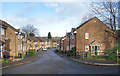
8
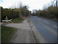
Bayswater Road
Bayswater Road passing Stowford Court
Image: © Shaun Ferguson
Taken: 20 Feb 2009
0.22 miles
9
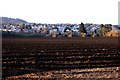
Path on the edge of Oxford
Suburban houses on the right, fields on the left. Oxford stops very suddenly just here.
Image: © Des Blenkinsopp
Taken: 3 Feb 2020
0.24 miles