IMAGES TAKEN NEAR TO
Avenue One, WITNEY, OX28 4YS
Introduction
This page details the photographs taken nearby to Avenue One, OX28 4YS by members of the Geograph project.
The Geograph project started in 2005 with the aim of publishing, organising and preserving representative images for every square kilometre of Great Britain, Ireland and the Isle of Man.

There are currently over 7.5m images from over14,400 individuals and you can help contribute to the project by visiting https://www.geograph.org.uk
Image Map
Images are licensed for reuse under creativecommons.org/licenses/by-sa/2.0
Notes
- Clicking on the map will re-center to the selected point.
- The higher the marker number, the further away the image location is from the centre of the postcode.
Image Listing (97 Images Found)
Images are licensed for reuse under creativecommons.org/licenses/by-sa/2.0
Image
Details
Distance
1
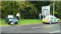
Oh, Dear!
Luckily no-one appears hurt, except the speed camera, on Ducklington Lane south of Witney.
Image: © Jonathan Billinger
Taken: 5 Aug 2008
0.08 miles
2
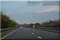
West Oxfordshire : The A40
Looking along the A40 heading through West Oxfordshire near Witney.
Image: © Lewis Clarke
Taken: 18 Mar 2019
0.10 miles
3
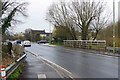
Station Lane, Witney, Oxon
A major road which runs to the south of the town centre. In the foreground it is crossing Emma's Dike by a bridge. See:- Image
The road on the right, in which a blue car is waiting, is Gordon Way.
Image: © P L Chadwick
Taken: 30 Mar 2018
0.10 miles
4
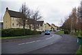
Gordon Way, Witney, Oxon
A modern residential road off Station Lane with a couple of similar roads branching off.
Image: © P L Chadwick
Taken: 30 Mar 2018
0.10 miles
5
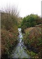
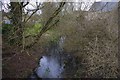
Emma's Dike, near Station Lane, Witney, Oxon
Emma's Dike is the name of this stream or watercourse which connects with the River Windrush. It is shown thus on old maps and some modern ones. On at least one of the latter it is named Em's Ditch, which seems rather unlikely. Here it is running south of Station Lane.
The name appears to come from a prominent historical Royal figure of the 11th century. Queen Emma was first married to King Ethelred ("the Unready") and following his death she married the Dane King Knut (Canute). One of her sons by her first marriage became King Edward the Confessor. Queen Emma owned land in Oxfordshire and in 1044 she granted the Bishop of Winchester an estate in Witney and this was confirmed in the Domesday Book. There is a street in Witney named Queen Emma's Dike and also a primary school is named after her.
Image: © P L Chadwick
Taken: 30 Mar 2018
0.10 miles
6
Electricity substation, Gordon Way, Witney, Oxon
A small substation serving the nearby modern residential development.
Image: © P L Chadwick
Taken: 30 Mar 2018
0.11 miles
7
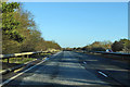
A40 towards Oxford
A little way ahead the A40 bridges over the A415 heading south from Witney.
Image: © Robin Webster
Taken: 19 Jan 2020
0.11 miles
8
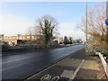
Station Lane, Witney
View looking towards the west as the road crosses Emma's Dyke on a cold frosty morning.
Image: © Richard Rogerson
Taken: 31 Jan 2019
0.11 miles
9
Emma's Dike, near Station Lane, Witney, Oxon
Looking from Station Lane. The houses in the distance on the left are in Gordon Way.
For more about Emma's Dike see:- Image
Image: © P L Chadwick
Taken: 30 Mar 2018
0.11 miles
10
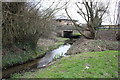
Stream beside Gordon Way
Here the stream passes under Station Lane on its way towards the River Windrush.
Image: © Roger Templeman
Taken: 10 Mar 2011
0.11 miles