IMAGES TAKEN NEAR TO
South Quay, ABINGDON, OX14 5TW
Introduction
This page details the photographs taken nearby to South Quay, OX14 5TW by members of the Geograph project.
The Geograph project started in 2005 with the aim of publishing, organising and preserving representative images for every square kilometre of Great Britain, Ireland and the Isle of Man.

There are currently over 7.5m images from over14,400 individuals and you can help contribute to the project by visiting https://www.geograph.org.uk
Image Map
Images are licensed for reuse under creativecommons.org/licenses/by-sa/2.0
Notes
- Clicking on the map will re-center to the selected point.
- The higher the marker number, the further away the image location is from the centre of the postcode.
Image Listing (83 Images Found)
Images are licensed for reuse under creativecommons.org/licenses/by-sa/2.0
Image
Details
Distance
1
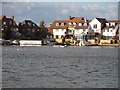
Abingdon Marina
An old gravel pit has been connected to the River Thames and developed as moorings and waterside housing.
Image: © Des Blenkinsopp
Taken: 2 Jun 2011
0.04 miles
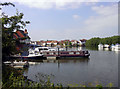
2

Boats at Abingdon Marina
Another shot showing the extent of this former gravel pit opened to the Thames as moorings and waterfront housing.
The yellow plant in the foreground is Bargeman's Cabbage Brassica rapa subsp. campestris (identified by Mick Crawley)
Image: © Des Blenkinsopp
Taken: 26 May 2011
0.07 miles
3
The Orange Way after Wiltshire (169)
The bridleway reaches Lambrick Lane in Abingdon and the walk goes ahead into West Quay.
Image: © Shazz
Taken: 9 Jul 2013
0.07 miles
4

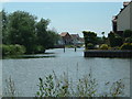
Abingdon Marina from Abingdon Marina Park
Looking across Abingdon Marina from the path that does a circuit around Abingdon Marina Park. In 1998, planning permission was granted for the marina facilities, as part of the comprehensive redevelopment of the area. The park is on an isthmus of dry land with the marina to the west and the River Thames to the north and east. Access to the park is down the functionally-named South Quay road, signposted 'River' from West Quay.
Image: © Jim Champion
Taken: 20 Jul 2020
0.09 miles
5
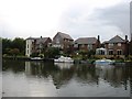
Abingdon Marina
The homes built on the north side of the marina seen from the slipway opposite.
Image: © Tim S Addison
Taken: 16 Oct 2008
0.10 miles
6
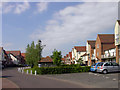
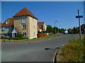
Marina Way, Abingdon
A gated cul-de-sac on the Abingdon Marina development which in spite of the name doesn't actually have waterside frontage.
This tall warehouse look with varied elevations and rooflines is a typical feature of the Marina Village.
Image: © Des Blenkinsopp
Taken: 26 May 2011
0.11 miles
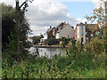
8
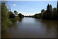
The River Thames near Abingdon Marina
The entrance to the marina is at the extreme left of the picture.
Image: © David Purchase
Taken: 6 Oct 2015
0.14 miles
9
Abingdon Marina
In the top right corner of the grid square. Taken looking south west from the Thames Path as it heads out of Abingdon on its way to London. A large chunk of this grid square is water.
Image: © Claire Ward
Taken: 19 Jun 2005
0.16 miles