IMAGES TAKEN NEAR TO
Wallace Close, ABINGDON, OX14 5LL
Introduction
This page details the photographs taken nearby to Wallace Close, OX14 5LL by members of the Geograph project.
The Geograph project started in 2005 with the aim of publishing, organising and preserving representative images for every square kilometre of Great Britain, Ireland and the Isle of Man.

There are currently over 7.5m images from over14,400 individuals and you can help contribute to the project by visiting https://www.geograph.org.uk
Image Map
Images are licensed for reuse under creativecommons.org/licenses/by-sa/2.0
Notes
- Clicking on the map will re-center to the selected point.
- The higher the marker number, the further away the image location is from the centre of the postcode.
Image Listing (11 Images Found)
Images are licensed for reuse under creativecommons.org/licenses/by-sa/2.0
Image
Details
Distance
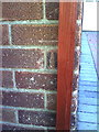
1
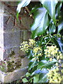
Benchmark on wall of Stenton Close outside #66 Baker Street
Ordnance Survey cut mark benchmark described on the Bench Mark Database at http://www.bench-marks.org.uk/bm22759
Image: © Roger Templeman
Taken: 4 Oct 2010
0.03 miles
2
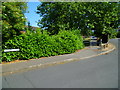
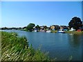
The Orange Way after Wiltshire (170)
The way to go is to leave North Quay and go ahead through the barrier.
Image: © Shazz
Taken: 9 Jul 2013
0.19 miles
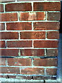
3
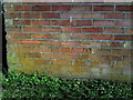
Benchmark on #85 Preston Road
Ordnance Survey cut mark benchmark described on the Bench Mark Database at http://www.bench-marks.org.uk/bm23105
Image: © Roger Templeman
Taken: 4 Oct 2010
0.19 miles
4
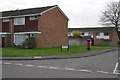
Junction of Preston Road and Kensington Close
There is an OS benchmark Image on the side of the house at the junction on the house itself and its porch extension.
Image: © Roger Templeman
Taken: 16 Feb 2013
0.19 miles
5
The Orange Way after Wiltshire (178)
Here's the view across the river to my earlier position by the riverside tree. The Orange Way follows the Thames Path for 64 miles from Abingdon to Windsor.
Image: © Shazz
Taken: 9 Jul 2013
0.21 miles
6
Benchmark on side of #246 Saxton Road
Ordnance Survey cut mark benchmark described on the Bench Mark Database at http://www.bench-marks.org.uk/bm22757
Image: © Roger Templeman
Taken: 4 Oct 2010
0.22 miles
8
Benchmark on #172 Saxton Road
Ordnance Survey cut mark benchmark described on the Bench Mark Database at http://www.bench-marks.org.uk/bm22758
Image: © Roger Templeman
Taken: 4 Oct 2010
0.23 miles
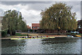
9
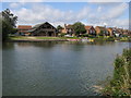
River Thames
River Thames by Abingdon School boathouse
Image: © Shaun Ferguson
Taken: 12 Sep 2012
0.23 miles
10
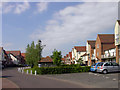
Marina Way, Abingdon
A gated cul-de-sac on the Abingdon Marina development which in spite of the name doesn't actually have waterside frontage.
This tall warehouse look with varied elevations and rooflines is a typical feature of the Marina Village.
Image: © Des Blenkinsopp
Taken: 26 May 2011
0.23 miles