IMAGES TAKEN NEAR TO
Rectory Lane, ABINGDON, OX13 5DS
Introduction
This page details the photographs taken nearby to Rectory Lane, OX13 5DS by members of the Geograph project.
The Geograph project started in 2005 with the aim of publishing, organising and preserving representative images for every square kilometre of Great Britain, Ireland and the Isle of Man.

There are currently over 7.5m images from over14,400 individuals and you can help contribute to the project by visiting https://www.geograph.org.uk
Image Map
Images are licensed for reuse under creativecommons.org/licenses/by-sa/2.0
Notes
- Clicking on the map will re-center to the selected point.
- The higher the marker number, the further away the image location is from the centre of the postcode.
Image Listing (11 Images Found)
Images are licensed for reuse under creativecommons.org/licenses/by-sa/2.0
Image
Details
Distance
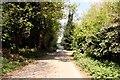
2
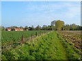
Farmland, Kingston Bagpuize
A restricted byway in arable fields to the north of Swannybrook Farm. To the left are a crop of oil-seed rape and the converted farm buildings of Race Farm.
Image: © Andrew Smith
Taken: 10 Apr 2011
0.15 miles
3
Rectory Lane in Kingston Bagpuize
Looking south towards the restricted byway to Swannybrook Farm.
Image: © Steve Daniels
Taken: 6 May 2013
0.16 miles
4
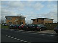
Kingston Bagpuize Business Park (New)
Like many old WW2 airfields RAF Kingston Bagpuize has become a business park. This is one of the modern units but behind here a row of the old 1940s round roof huts are still in use.
Image: © Des Blenkinsopp
Taken: 22 May 2012
0.19 miles
5
Rectory Lane in Kingston Bagpuize
Looking north towards Kingston Bagpuize.
Image: © Steve Daniels
Taken: 6 May 2013
0.20 miles
6
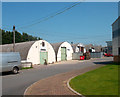
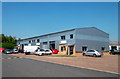
Kingston Bagpuize Business Park (Old)
Like many old WW2 airfields RAF Kingston Bagpuize has become a business park.
Most of the units are new but this row of original wartime huts is still in use.
Image: © Des Blenkinsopp
Taken: 22 May 2012
0.22 miles
7
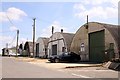
Former military buildings in Kingston Bagpuize Park
The business park is on the site of the former RAF Kingston Bagpuize.
Image: © Steve Daniels
Taken: 6 May 2013
0.23 miles
8
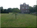
Kingston Bagpuize House (2)
This photo shows the North side of Kingston Bagpuize House which is set in 30 acres of parkland and surrounded by gardens. The lawns can be seen in front of the house.
Image: © David Hillas
Taken: 28 Jul 2014
0.23 miles
9
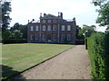
Kingston Bagpuize House (1)
This photo shows Kingston Bagpuize House with the lawn in front of it. It was built prior to 1670 in the reign of Charles II, and is probably the work of Sir Roger Pratt, a pupil of Inigo Jones. In the 20th Century, it was the home of John Buchan, 2nd Baron Tweedsmuir, the son of the novelist John Buchan, 1st Baron Tweedsmuir. It is now open on various Sundays, Mondays and Tuesdays between March and September.
Image: © David Hillas
Taken: 28 Jul 2014
0.23 miles
10
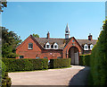
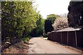
Entrance to the Stables
Beside Kingston Bagpuize House. The stable units are now let to businesses.
Image: © Des Blenkinsopp
Taken: 22 May 2012
0.24 miles