IMAGES TAKEN NEAR TO
The Towpath, Hythe Bridge Street, OXFORD, OX1 2TA
Introduction
This page details the photographs taken nearby to The Towpath, Hythe Bridge Street, OX1 2TA by members of the Geograph project.
The Geograph project started in 2005 with the aim of publishing, organising and preserving representative images for every square kilometre of Great Britain, Ireland and the Isle of Man.

There are currently over 7.5m images from over14,400 individuals and you can help contribute to the project by visiting https://www.geograph.org.uk
Image Map
Images are licensed for reuse under creativecommons.org/licenses/by-sa/2.0
Notes
- Clicking on the map will re-center to the selected point.
- The higher the marker number, the further away the image location is from the centre of the postcode.
Image Listing (1249 Images Found)
Images are licensed for reuse under creativecommons.org/licenses/by-sa/2.0
Image
Details
Distance
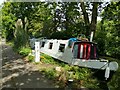
1
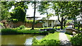
Oxford - end of the Canal
Near to the centre of Oxford, this is the limit of navigation; a spur just beyond Isis Lock. Moorings commence about 100 yards back from this location.
Image: © Peter Trimming
Taken: 30 May 2009
0.01 miles
4
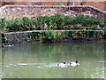
Horseshoe weir at Hythe Bridge
This is an overflow weir on the Oxford canal immediately to the north of Hythe Bridge, where the canal now comes to an end. It was built in 1822 to replace an earlier flash lock.
Image: © Natasha Ceridwen de Chroustchoff
Taken: 15 May 2009
0.01 miles
5
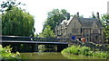
Hythe Bridge, Oxford
Photographed from the footpath between the river and the southern terminus on the canal. The Oxford Retreat PH is seen beside the bridge.
Image: © Peter Trimming
Taken: 30 May 2009
0.02 miles
6
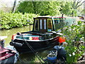
Charging point on the Oxford Canal
Moorings at the southern end of the canal, with power supply.
Image: © Stephen Craven
Taken: 21 Sep 2021
0.02 miles
7
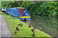
End of the canal
This is where the Oxford Canal stops now with a overflow weir to the left.
Image: © Bill Nicholls
Taken: 23 Jul 2009
0.02 miles
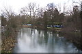
9
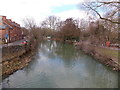
Castle Mill Stream, Oxford
Viewed from Hythe Bridge. Castle Mill Stream is a backwater of the River Thames.
Upper Fisher Row http://www.geograph.org.uk/photo/3392019 is on the left.
Image: © Jaggery
Taken: 31 Mar 2013
0.02 miles
10
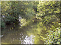
Oxford Canal
The canal from Hythe Bridge Street.
Image: © David Dixon
Taken: 8 Aug 2010
0.02 miles